The 40-acre site is located entirely within the arid Mojave Desert, approximately 30 miles south of the City of Las Vegas and 6 miles west of the community of Searchlight. This area receives an average of about 8 inches of rainfall per year. Table 3.2, “Monthly Average Rainfall at the Community of Searchlight in Clark County, 1931-1995” shows the average annual rainfall for the community of Searchlight.
Table 3.2. Monthly Average Rainfall at the Community of Searchlight in Clark County, 1931-1995
| Jan | Feb | Mar | Apr | May | Jun | Jul | Aug | Sep | Oct | Nov | Dec | Year | |
|---|---|---|---|---|---|---|---|---|---|---|---|---|---|
| mm | 21.4 | 22.2 | 21.6 | 9.7 | 5.4 | 2.6 | 24.6 | 29.8 | 17.8 | 12.4 | 12.8 | 21.6 | 202.9 |
| inches | 0.8 | 0.9 | 0.9 | 0.4 | 0.2 | 0.1 | 1 | 1.2 | 0.7 | 0.5 | 0.5 | 0.9 | 8 |
| Source: SEARCHLIGHT CLARK COUNTY data derived from NCDC Cooperative Stations. 57 complete years between 1931 and 1995. | |||||||||||||
Most months average between 0.5 inch and 1.0 inch of rain. Although the area is typically dry, occasional high intensity and large volume rainfall events occur. These infrequent, large rainfall events can produce large amounts of runoff from the upper reaches of the watershed, and may result in flash flooding within the natural collection channels and washes.
The infrequent nature of rainfall in this part of the country results in only intermittent channelized flow on the project site; there are no permanent streams or surface waters within the analysis area.
The topography of the site encourages runoff to flow across the headquarters area (40 acres) from west/northwest to east/southeast. The contributing watershed is approximately 444 acres, including a portion of the hills to the west of the project. Resulting runoff from a 100-year discharge event can be as much as 30 cfs flowing in a series of shallow swales and rivulets across the site.
Natural drainage channels on the site are generally shallow and wide. Many of them are no more than a few inches and spread 5-10 feet wide. The larger on-site channels are approximately a foot or so deep and 10-15 feet wide.
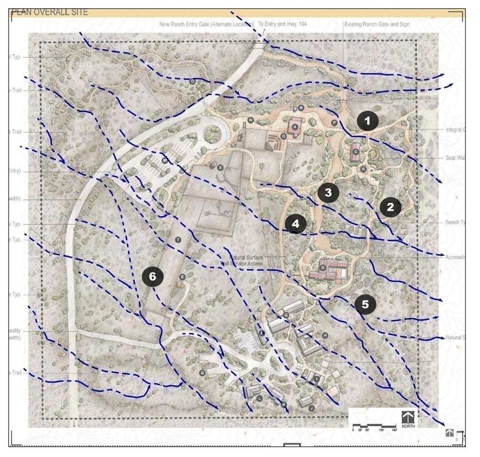
Figure 3.1, “Walking Box Site Hydrology - Existing Drainage Pattern Across Site” shows existing surface runoff patterns on the project site. There are four distinct areas of concentrated flow that convey rainfall runoff from the watershed west of the property through the site. From north to south, the major flow paths that cross the site are 1) north of the main gate, 2) north of the ranch house, 3) south of the ranch house, and 4) south of the caretaker’s residence. There are several other swales that collect on-site drainage and act as tributaries to the more major flow paths.
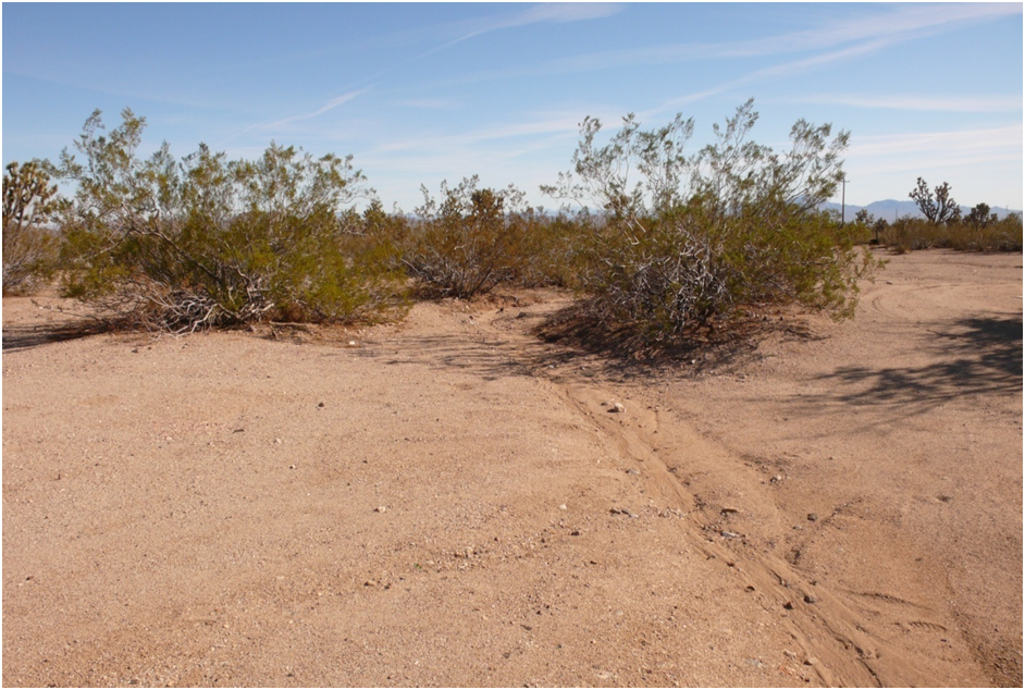
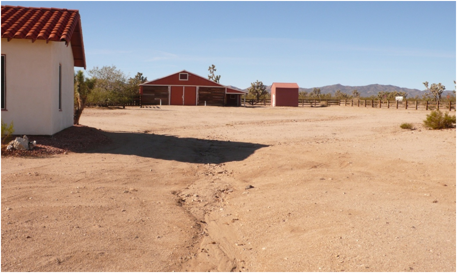
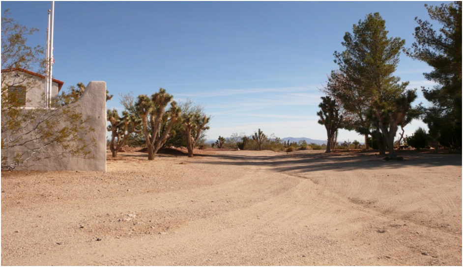
The existing buildings on site are at an elevation very near the existing drainage conveyance channel elevation and, as a result, are exposed to potential flooding. It is likely that during larger rainfall events, the exterior of some of the buildings comes in contact with stormwater flowing across the site. No damage has been observed to the buildings from these flows, but the potential is obvious with the close proximity and grade to the conveyance channels as shown in Figure 3.2, “Larger On-Site Existing Stormwater Conveyance Channel”, Figure 3.3, “Example of Existing Stormwater Conveyance Channel Adjacent to Structure”, and Figure 3.4, “Existing Stormwater Conveyance Channel”.

Click here for a larger view (figure opens in a new window).
Figure 3.1. Walking Box Site Hydrology - Existing Drainage Pattern Across Site
 |
Click here for a larger view (figure opens in a new window).
Figure 3.2. Larger On-Site Existing Stormwater Conveyance Channel
 |
Click here for a larger view (figure opens in a new window).
Figure 3.3. Example of Existing Stormwater Conveyance Channel Adjacent to Structure
 |
Click here for a larger view (figure opens in a new window).
Figure 3.4. Existing Stormwater Conveyance Channel
As the stormwater flows travel to lower elevations and flatter grades, the runoff begins to fan out in very shallow and wide flow paths across the valley. At this point, some portion of runoff will make its way to groundwater aquifers. Groundwater in this region tends to be quite deep.
Groundwater Resources
The Walking Box Ranch 40-acre parcel has two water wells. One well was drilled to 920 feet in 1964; the second well was drilled to 1,095 feet in 1992. The 1964 well is now abandoned – it is reported that a pump was dropped into the well, making it inoperable. The 1992 well is the only water supply on site.
The drilling report for the 1992 well shows that the static water table was encountered at 700 feet, and it was air-lift tested at 20 gallons per minute (gpm). The well hole diameter is 12 inches down to 535 feet and 8 inches from 536 feet to the bottom (1,095 feet) (State of Nevada Division of Water Resources Well Driller’s Report # 38903, 7/6/1992).
A submersible pump is used to draw water from the 1992 well; this water is stored in a 7,500- gallon (est.) water storage tank at the southwest end of the main ranch house headquarters area. Recently the well pump was replaced with a new 5 HP, 3 phase unit. Pumping tests were performed on the well using this new pump in December 2007. The results of the recent testing show the water fluctuating from a depth of 650 initially to a maximum depth of 795 feet. The pumping rate fluctuated between 5.6 and 12.2 gpm, with an average of 8.7 gpm over a 24-hour well test period. Since most of the pumping rates in the later part of the test were ranging from 7.3-9.0 gpm, it is reasonable to assume a sustainable pumping rate in the 7-8 gpm range. A pumping rate of 7 gpm yields 10,080 gallons per day.
A water quality report shows that a water sample taken 12/12/2008 exceeded state limits for arsenic and fluoride. Coliform levels were noted in this test as well. The well was cleaned and a follow-up water quality sample was taken 12/17/08. No coliform was present in the second sample.
Adjacent to the large potable water storage tank is a structure housing water softening and pressurizing equipment, which is used to adjust the pH and bring it up to potable water standards. Softened water is pressurized and stored in a 2,500-gallon pressurized tank. The pressurized and softened water is delivered to the ranch house, bunkhouse, and caretaker’s home.
BLM has determined that the ranch has 13,755 acre-feet per year of water rights associated with the property and has finalized the transfer of these rights to their name. This translates to approximately 4.48 million gallons yearly or 12,275 gallons per day (a typical residence uses approximately 500-1,000 gallons per day).