Management actions that restrict or constrain the potential for oil and gas leasing, development, and exploration (via NSO, CSU, and TLS restrictions or managing areas as administratively unavailable) would result in adverse impacts; management actions that ease restrictions or maintain areas as open for oil and gas exploration and development would result in beneficial impacts. All of the alternatives include management that restricts oil and gas leasing and development to varying levels; Alternative B would generally result in the most adverse impacts to oil and gas development and Alternative C the least. Figure 4–3 displays the acreage open to oil and gas development subject to the standard lease form, open with constraints, and administratively unavailable under each alternative. Areas administratively unavailable for oil and gas development are smallest under Alternative C (147,760 acres) and largest under Alternative B (2,296,279 acres). Alternative C has the largest amount of area open to oil and gas development subject to the standard lease form only, followed by alternatives A, D, and B. Areas open with moderate and major constraints are largest under Alternative D, followed by alternatives A, C, and B (because most of the Planning Area is administratively unavailable under Alternative B). Impacts to oil and gas exploration and development from the restriction of geophysical exploration would be the greatest under Alternative B due to limits on motorized vehicle use and restrictions on surface-disturbing activities. Adverse impacts result when management of special designations (e.g., ACECs and National Historic Trails [NHTs]) places restriction on oil and gas leasing or makes areas administratively unavailable for oil and gas leasing (see Table 4–6). Additionally, the BLM manages Wild Lands as administratively unavailable for oil and gas leasing under alternatives B (565,868 acres of federal mineral estate) and D (47,469 acres of federal mineral estate), except for the Painted Hills Wild Land under Alternative D which is available for leasing with an NSO restriction.. Alternatives C and D establish Oil and Gas Management Areas (568,164 acres and 134,214 acres, respectively) allowing full development of known oil and gas resources in existing fields and exempting these areas from seasonal development and other restrictions, resulting in beneficial impacts to oil and gas exploration and development. As shown in Table 4–7, alternatives B and D are the only alternatives where areas managed as administratively unavailable to oil and gas leasing include some areas with moderate development potential (219,821 acres and 2,834 acres, respectively). The development potential for leasable oil and gas in the Planning Area ranges from moderate to no potential, depending on location.
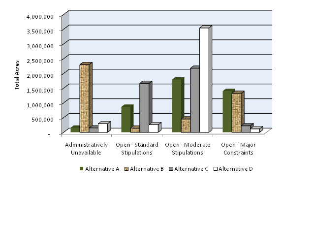
Table 4.6. Acres of Federal Mineral Estate Closed or Administratively Unavailable for Oil and Gas Leasing due to Special Designations and Other Management Areas1
| Type of Area | Alternative A | Alternative B | Alternative C | Alternative D |
|---|---|---|---|---|
| Wilderness Study Areas | 142,031 | 142,031 | 142,031 | 142,031 |
| Wild Lands | 0 | 565,868 | 47,469 | 0 |
| National Historic Trails | 0 | 0 | 0 | 0 |
| National Historic Landmark | 0 | 12,506 | 833 | 833 |
| Areas of Critical Environmental Concern | 11,928 | 340,863 | 8,560 | 78,993 |
| Wild and Scenic Rivers | 14,330 | 21,863 | 0 | 0 |
| Absaroka Front Management Area | 0 | 217,122 | 0 | 85,634 |
| Special Recreation Management Areas | 0 | 0 | 0 | 0 |
Source: BLM 2009a
1Acreages provided indicate areas administratively unavailable or closed to leasing as a direct result of the management of the special designation or other management area. Other areas may be administratively unavailable or closed to leasing as a result of other overlapping resource considerations.
Table 4.7. Acres of Oil and Gas Development Potential and Constraints by Alternative
| Development Potential | Constraint | Alternative A | Alternative B | Alternative C | Alternative D |
|---|---|---|---|---|---|
| Moderate | Closed or Administratively Unavailable1 | 0 | 219,821 | 0 | 2,834 |
| Standard Stipulations | 82,703 | 10,228 | 128,933 | 18,775 | |
| Moderate Constraints | 164,105 | 31,726 | 203,238 | 319,310 | |
| Major Constraints | 97,731 | 82,764 | 12,368 | 3,621 | |
| Low | Closed or Administratively Unavailable1 | 0 | 887,853 | 0 | 3,689 |
| Standard Stipulations | 416,271 | 81,158 | 905,847 | 83,789 | |
| Moderate Constraints | 828,800 | 167,729 | 797,216 | 1,656,939 | |
| Major Constraints | 547,837 | 656,169 | 89,846 | 48,491 | |
| Very Low | Closed or Administratively Unavailable1 | 9,373 | 978,427 | 5,752 | 93,149 |
| Standard Stipulations | 338,930 | 47,605 | 579,249 | 133,078 | |
| Moderate Constraints | 759,059 | 234,633 | 1,122,828 | 1,531,662 | |
| Major Constraints | 713,710 | 560,407 | 113,243 | 63,183 | |
| None | Closed or Administratively Unavailable1 | 3,479 | 68,087 | 0 | 52,624 |
| Standard Stipulations | 25,646 | 48 | 48,380 | 20,862 | |
| Moderate Constraints | 37,649 | 17,859 | 52,524 | 30,782 | |
| Major Constraints | 40,126 | 20,908 | 5,997 | 2,672 |
Source: BLM 2009a
1 There are no oil and gas development potential data for Wilderness Study Areas (143,974 acres), and the data in this table do not reflect those areas. All Wilderness Study Areas are closed to new leasable mineral exploration and development (BLM Manual 8550 - Interim Management Policy and Guidelines for Lands Under Wilderness Review).