3.3.11.1 Affected Environment
For the purpose of this EA the Affected Environment for the proposed oil and gas leasing area is the same as that described
in Section 3.5 of the RMP/FEIS.
The Ely District BLM authorizes livestock grazing use on all allotments which overlap the proposed oil and gas leasing area.
Relevant information for the allotments is presented in the Table below.
|
O&G Group
|
Allotment Name
|
GIS Acres
|
Active AUMs
|
GIS_ACRES in Project
|
Percentage of Allotment Potentially Affected
|
Season of Use
|
|
|---|---|---|---|---|---|---|---|
|
D
|
Badger Spring
|
33765
|
1412
|
1537
|
5
|
15-Apr
|
30-Nov
|
|
D
|
Cold Creek
|
64841
|
5803
|
39
|
>1
|
15-Apr
|
15-Nov
|
|
B
|
Cove
|
28199
|
1544
|
1626
|
6
|
1-Nov
|
15-Apr
|
|
B
|
Dark Peak
|
19669
|
1826
|
1650
|
8
|
1-Apr
|
1-Nov
|
|
D
|
Duckwater
|
849127
|
20100
|
1400
|
>1
|
1-Mar
|
28-Feb
|
|
C
|
Duckwater
|
849127
|
20100
|
13959
|
2
|
1-Mar
|
28-Feb
|
|
B
|
Forest Moon
|
118805
|
2263
|
1480
|
1
|
1-May
|
28-Feb
|
|
B
|
Fox Mountain(East)
|
73557
|
3732
|
55
|
>1
|
1-Nov
|
10-Apr
|
|
A
|
Garden Spring
|
39209
|
1685
|
1
|
>1
|
1-Nov
|
30-Apr
|
|
A
|
Gourd Spring
|
97536
|
3458
|
29046
|
30
|
1-Oct
|
31-May
|
|
B
|
Hardy Spring
|
125652
|
3478
|
3258
|
3
|
1-Mar
|
28-Feb
|
|
D
|
Jakes Unit Trail
|
32735
|
832
|
1021
|
3
|
1-Apr
|
30-Apr
|
|
D
|
Jakes Unit Trail
|
32735
|
832
|
1021
|
3
|
1-Nov
|
30-Nov
|
|
A
|
Lime Mountain
|
62602
|
6754
|
152
|
>1
|
1-Oct
|
15-May
|
|
D
|
Maverick Springs
|
46630
|
1500
|
57
|
>1
|
1-Mar
|
28-Feb
|
|
D
|
Medicine Butte
|
310967
|
7701
|
1299
|
>1
|
1-Mar
|
28-Feb
|
|
D
|
Moorman Ranch
|
135877
|
4740
|
1606
|
1
|
1-Mar
|
28-Feb
|
|
A
|
Mormon Peak
|
77991
|
330
|
3550
|
5
|
1-Oct
|
30-May
|
|
B
|
North Cove
|
40101
|
1335
|
3824
|
5
|
1-Nov
|
1-Jul
|
|
A
|
Snow Springs
|
44377
|
3574
|
29449
|
66
|
1-Oct
|
15-May
|
|
A
|
Summit Spring
|
17621
|
429
|
2723
|
15
|
1-Nov
|
30-Apr
|
|
B
|
Sunnyside
|
226959
|
5402
|
13582
|
6
|
1-Jun
|
31-Mar
|
|
A
|
Terry Bench
|
30163
|
698
|
16182
|
54
|
16-Nov
|
15-Mar
|
|
D
|
Warm Springs
|
362941
|
7740
|
11269
|
3
|
1-Apr
|
15-Oct
|
|
B
|
Wells/Dee Gee
|
31204
|
1327
|
1729
|
6
|
1-Nov
|
1-Jul
|
|
B
|
White River Trail
|
35594
|
1505
|
1774
|
5
|
1-Jun
|
31-Mar
|
|
A
|
White Rock
|
32983
|
1728
|
981
|
3
|
1-Nov
|
30-Apr
|
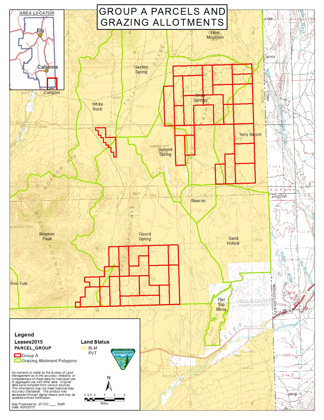
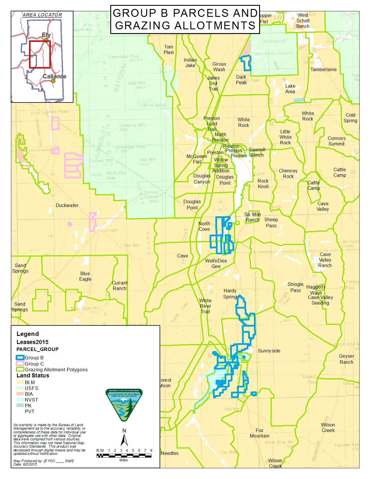
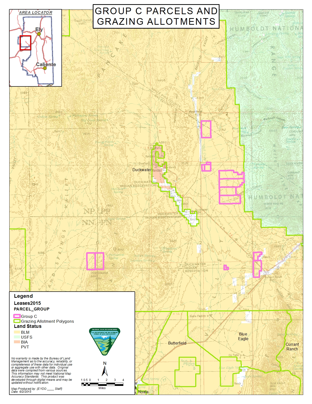
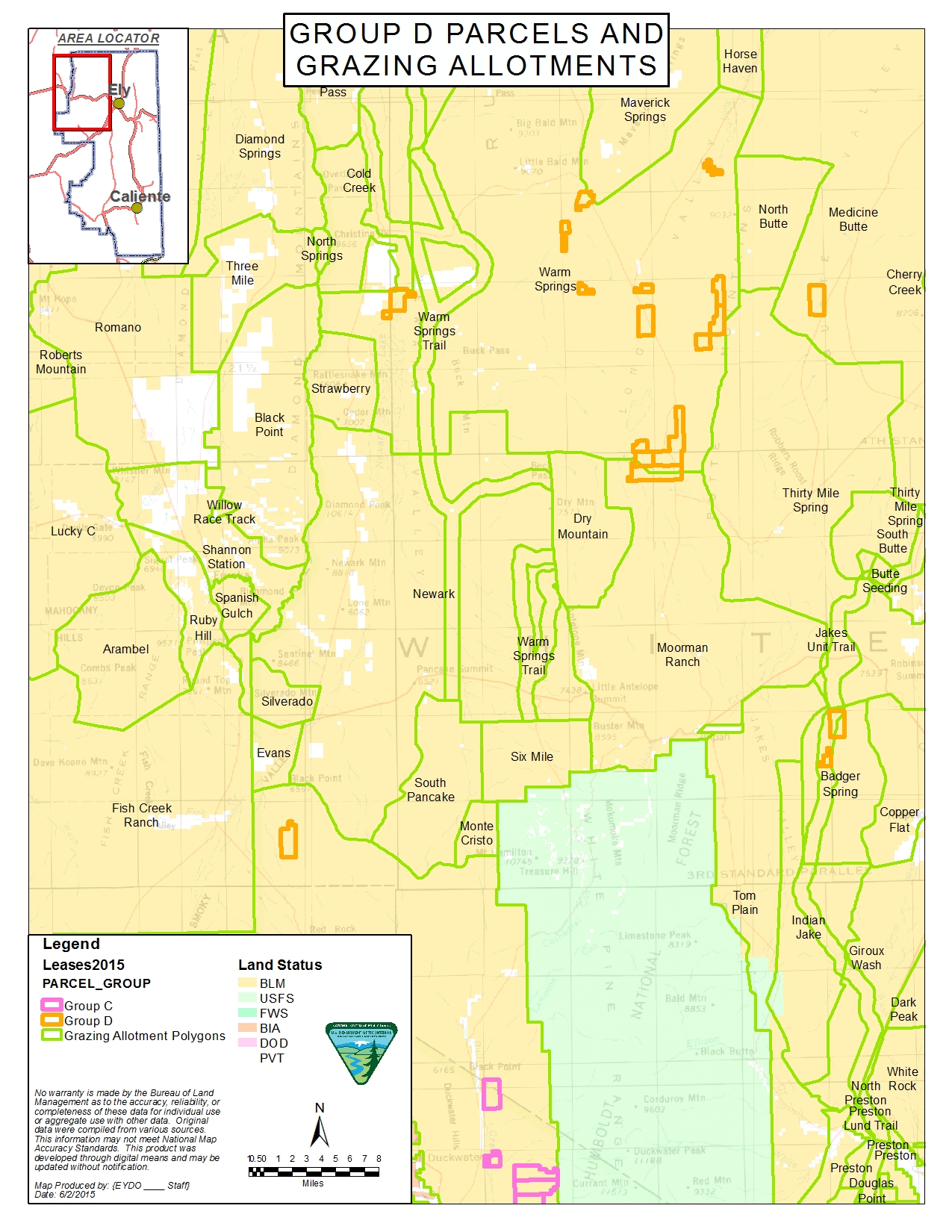
Allotments overlapping each of the six parcel groups are shown on four Maps below.
Map 1 Maps of Group A Parcels Overlapping Allotments

Map 2 Map of Group B Parcels Overlapping Allotments

Map 3 Map of Group C Parcels Overlapping Allotments

Map 4 Map of Group D Parcels Overlapping Allotments

All livestock grazing allotments within the project area are classified as perennial allotments. Term permits authorize grazing
use based on perennial vegetation. Authorized grazing use includes both cattle and sheep. The majority of livestock grazing
authorized is for cattle grazing. Allotment grazing periods of use vary and include both seasonal and yearlong. Seasons include
fall/winter/spring period and spring/summer/fall period. Grazing systems may include rest-rotation, deferred rotation, and
deferred rest rotation. Allotments that are grazed both yearlong and seasonally include herding of cattle and sheep between
public land allotments, base property, other leased or private pasture and U.S. Forest Service-administered lands. Some allotments
are grazed in common by two or more livestock permittees. Livestock are either mixed together in the same use area or graze
in separate use areas of the allotment. Authorized grazing use is in accordance with established use periods or seasons of
use for the allotment.
Livestock grazing allotments within parcel group A in Lincoln County and are within the Mojave desert ecological system. The
Mojave - Southern Great Basin Area Standards and Guidelines for grazing administration apply to livestock grazing for these
groups. Restoration in the Mojave Desert ecosystem is especially difficult due to xeric conditions.
Livestock grazing allotments within group B, C, and D are in White Pine and Nye Counties and are within the Great Basin ecological
system.