3.3.5 Soils
Affected Environment
Soil Formations
Soils within the lease parcel area are largely a product of the local geologic parent material, climatic conditions, and topographic
position on the landscape. The dominant geologic formation is Mancos Shale, and weathers to produce fine-textured, silty
clay loam soils. Mancos Shale is a sedimentary marine evaporite, naturally high in dissolved salts and selenium.
Figure 1 Highly erodible Mancos Shale dominates the local landscape of the Adobes.
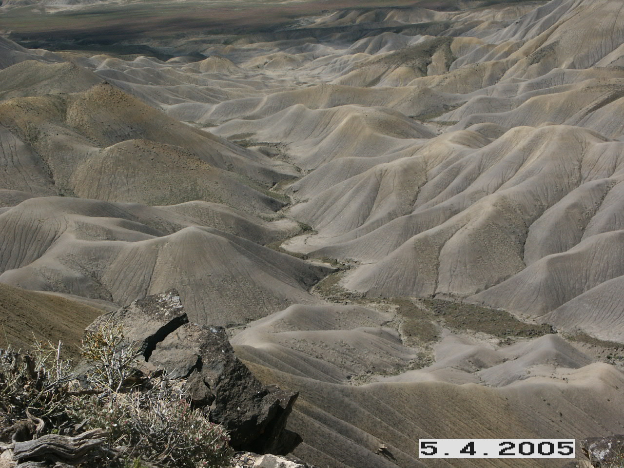
Figure 3.3 Mancos Shale above shows typical Mancos Shale topography in an area known locally as “the Adobes.” The highly erodible nature of the
shale is evidenced in the photograph by the natural rilling, gullying, and mass wasting. Steep slopes and sparse vegetation
contribute to making the adobe hills vulnerable to elevated rates of erosion during summer months when monsoonal thunderstorm
events occur.
Figure 1 Biological Soil Crusts are a critical component of Mancos Shale.
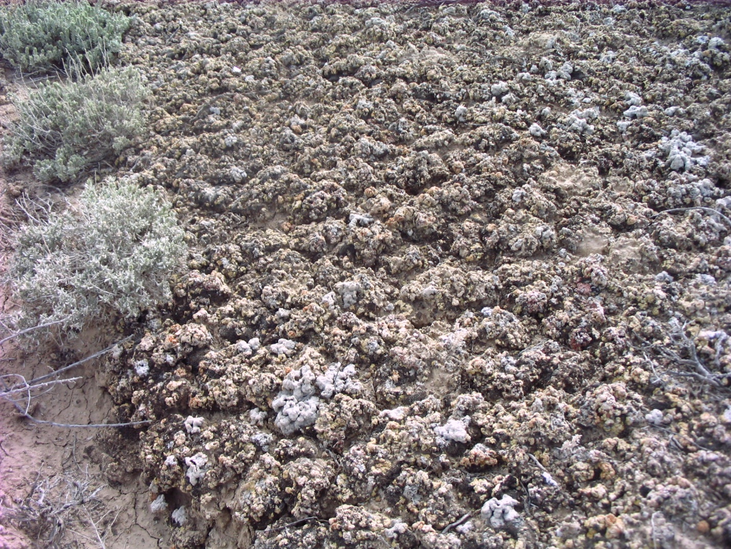
In other areas within the lease sale area where adobes aren’t present, deep soils with little rock content exist on mesa top
interiors and alluvial valleys. Shallow rocky soils are commonly found on mesa rims and along the side slopes of canyons.
Soils found at these higher elevations are typically classified as Alfisols (with a high level of subsoil development) and Mollisols (with a darkened organic matter-enriched surface). Soils found in lower adobe formations of the lease sale area have little
organic matter throughout their vertical profile and are predominantly classified as Aridisols (found in dry climate regimes) and Entisols (with a limited profile development).
Saline/Selenium Soils
Selenium is a naturally-occurring soluble metal commonly found in marine sediments such as Mancos Shale. Easily mobilized
salts are also a typical component of this formation. Selenium and salts can be mobilized by irrigation water application
or surface-disturbing activities, and transported to nearby waterways through irrigation return, groundwater, or overland
flows. Soils derived from Mancos Shale can have varying selenium and salt concentrations depending on soil member. Table 3.9 belowwas compiled from unpublished data collected in 2007 by the Colorado State Geological Survey (Morgan and Noe) in the nearby
Gunnison Gorge National Conservation Area.
Table 13 Stratigraphy and Chemical Characteristics of the Mancos Shale Formation in the Gunnison Gorge National Conservation
Area
|
Geologic Formation |
Formation Member |
Chemistry* |
||
|
Mancos Shale |
Prairie Canyon
|
No data available
|
||
|
Smoky Hill
|
Moderate carbonate carbon, low sulfur, moderate selenium
|
|||
|
Fort Hayes
|
||||
|
Montezuma Valley
|
Highest carbonate carbon
|
Highest selenium
|
Soils developed on these members have higher salinity and selenium than other members
|
|
|
Juana Lopez
|
Highest Sulfur
|
|||
|
Blue Hill
|
Highest sodium
|
|||
|
Fair Port
|
||||
|
Bridge Creek
|
Low to moderate in all measured constituents
|
|||
|
Green Horn
|
No data available
|
|||
|
Graneros
|
No data available
|
|||
|
Dakota Sandstone |
||||
|
*The high, moderate, and low descriptors for the chemistry constituents are based on comparisons of the concentrations between
the geologic members.
|
||||
In addition to the variability of Selenium concentrations depending on the formation member, the solubility or ability to
be transported can vary by location. The Colorado River Conservation District and Natural Resources Conservation Service
prepared a GIS model depicting the potential solubility of various soils in the Mancos soil formation (CRWCD, 2010). The
model uses soil chemistry, precipitation data (PRISM), and topography to rank the potential selenium solubility. Figure 3.5 depicts the areas with a higher rank or higher potential for transport.
Selenium presents a problem once soil formations with high solubility become saturated. Upon saturation, selenium is leached
into nearby waterways. In the larger rivers, it becomes concentrated and accumulates in low to zero velocity habitats such
as backwaters and enters the food chain. Agricultural practices in particular have resulted in both the Gunnison and Colorado
rivers having higher than desired levels of selenium. Selenium concentrations of 4.9-7.0 µg/g dry weight in whole body fish
from the Colorado River basin have been among the highest in the nation (Hamilton et al. 2002). Selenium bioaccumulates in
fish tissue primarily via the consumption of food resources that contain elevated levels of the metal. Colorado pikeminnow
are especially at risk given their piscivorous (fish eating) nature. Research has shown that high selenium levels may adversely
affect reproduction and recruitment of these fishes (Hamilton and Wiedmeyer 1990; Stephens et al. 1992; Hamilton and Waddell
1994; Hamilton et al. 1996; Stephens and Waddell 1998; Osmundson et al. 2000).
Figure 1 Saline and Selenium Soils
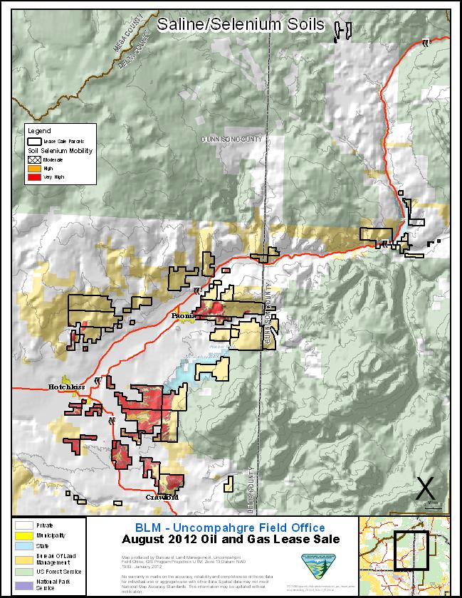
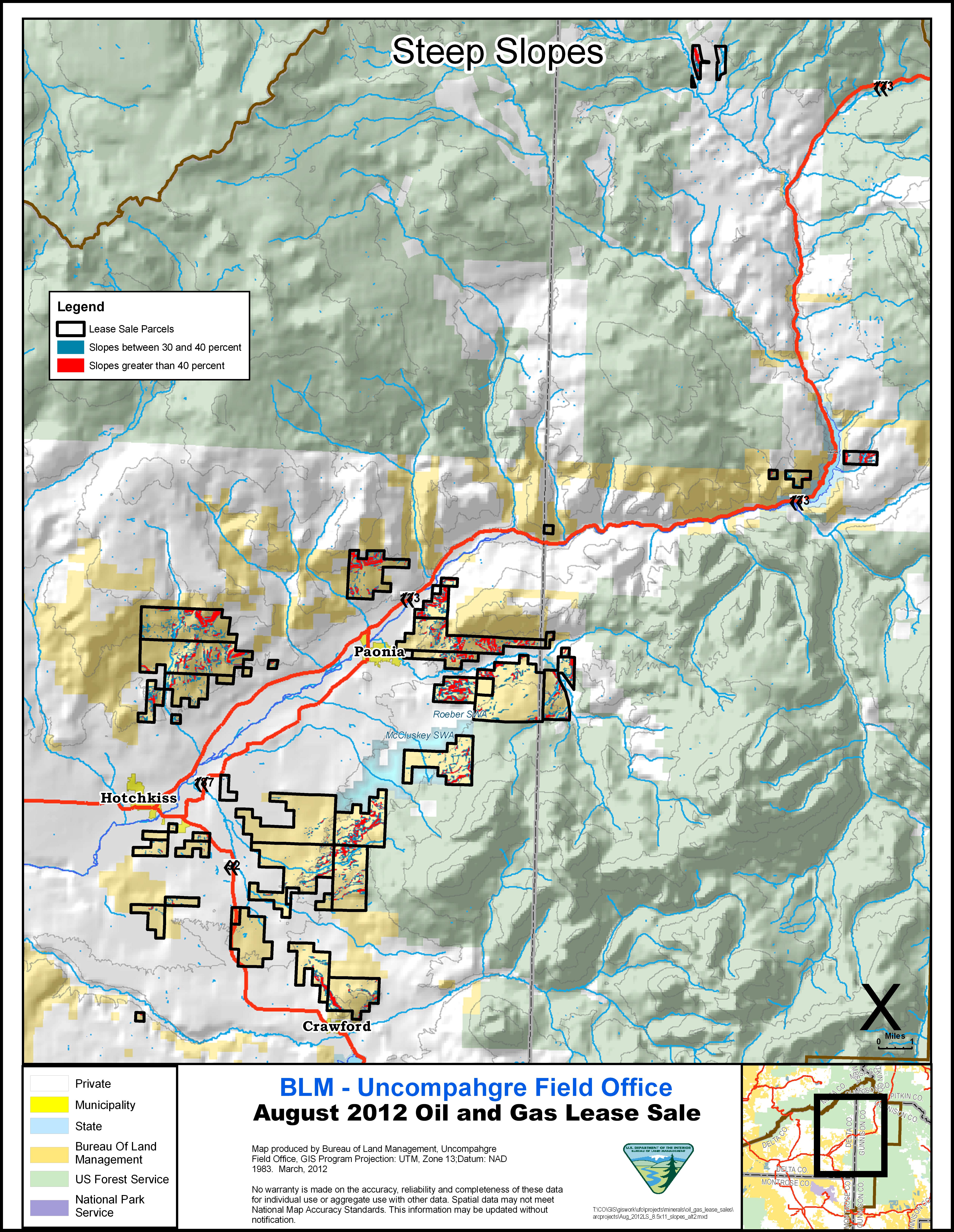
Figure 1 Steep Slopes
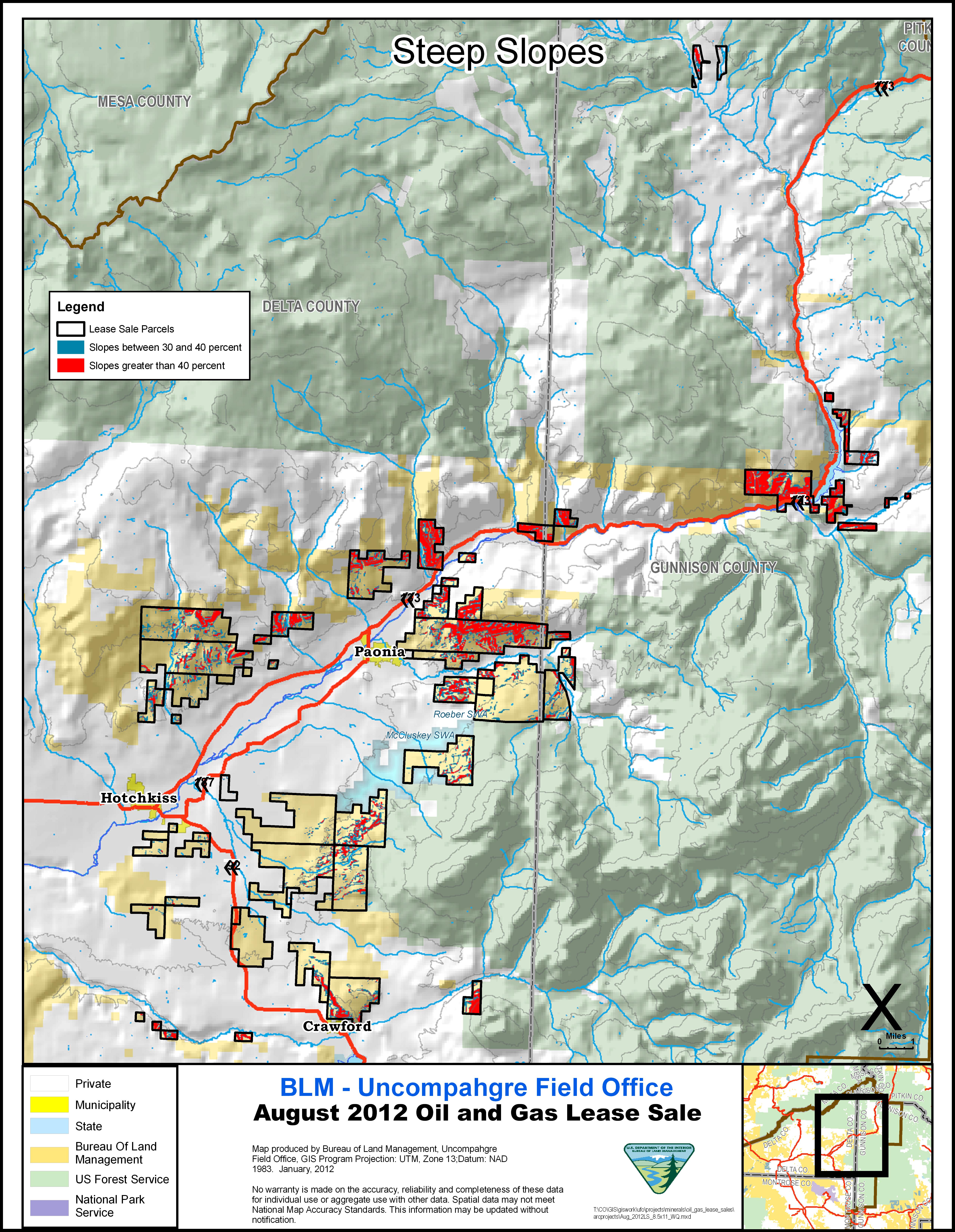
Steep Slopes
Slopes of greater than 30 percent pose concerns for reclamation and long-term soil health and productivity. As shown in Figure 3.6 Steep Slopes, 3,770 acres within the lease parcel area consist of terrain with slopes of between 30 and 40 percent and 5,903 acres have
slopes of greater than 40 percent. Slopes in this range are prone to accelerated erosion and require additional protection
measures to ensure that site productivity is restored and surface runoff is prevented.
Environmental Effects
Proposed Action
While the act of leasing the parcels would produce no impacts, subsequent development of the lease would lead to surface disturbance
from the construction of well pads, access roads, and pipelines. The scope and extent of the impacts would be analyzed in
accordance with NEPA at the time of exploration and development and would be proposed in an Application for Permit to Drill
(APD). Some of the known potential impacts associated with oil and gas activities that could occur on these lease parcels
include:
| • | Disturbance of the soil profile, resulting in the mixing of soil horizons and compaction. |
| • | Removal of vegetation, exposing the soil to wind and water erosion. |
| • | Increased sediment transport, through erosion processes such as sheet, gully, rill erosion, and mass movement. |
| • | Development on steep slopes, requiring cut and fill. |
| • | Soil contamination with drilling and production fluids. |
| • | Difficulty in reclamation associated with loss of soil productivity. |
Development on Mancos Shale could increase the intensity of many of the impacts above due to the erosive nature of soils.
Any activities associated with BLM management that would disturb identified Mancos shale soils and make them available for
transport via erosion or sedimentation into water would likely increase selenium levels in nearby streams and rivers. The
increase in selenium concentrations could impact downstream resources including endangered fish In addition, reclamation
on this soil formation is likely to be very difficult due to lack of moisture, steep slopes and disturbance of the biological
soil crust.
Cumulative Effects
This lease sale, when combined with the past, present and reasonably foreseeable actions, could elevate the potential for
deterioration of soil health. Surface disturbance associated with oil and gas activities could magnify other impacts from
activities on private and federal lands in the watershed. Other activities causing impacts to soils on BLM and Forest Service
lands in the watershed include: coal mining, grazing, rights of ways, recreation and travel infrastructure. Impacts to soils
also result from activities associated with private property in the watershed, including: cultivation, irrigation, livestock
production, residential and commercial land development, coal mining, and oil and gas development. The types of impacts expected
from other actions in the watershed would be similar to those described for the proposed action. The cumulative effect of
all the impacts in the watershed could contribute to decreased soil health.
Mitigation
All or portions of parcels (6197, 6199, 6198, and 6203) if offered for lease are subject to Exhibit UB-01 to protect Highly
erodible and/or saline soil areas.
To reduce the potential environmental effects of transport of selenium into water populated by Threatened or Endangered fish
species if development was to occur, the following Exhibit should be applied to the following parcels; 6189, 6190, 6191, 6192, 6193, 6194, 6195, 6196, 6197, 6198, 6199, 6200, 6201, 6202, 6203, 6205, 6207, 6217:
| 1. | CO-34 -ENDANGERED SPECIES ACT SECTION 7 CONSULTATION STIPULATION |
The full text of CO-34 is located in Appendix F. The stipulation will be used should analysis show that activities in areas with high selenium concentrations would cause
transport of selenium to surface waters containing Threatened or Endangered fish species. As stated in the stipulation, the
BLM may recommend modifications to exploration and development proposals to further its conservation and management objective
to avoid BLM-approved activity that will contribute to a need to list such a species or its habitat. For example, BLM may
require surface use plans to be approved by the Authorized Officer, which would include measures to limit runoff or mobilization
on saline/selenium soils. BLM may require measures to prevent the deep percolation of groundwater within saline/selenium soils.
Required measures may include engineered leak prevention of drilling system pits containing fluids such as flowback and stimulation
fluids, produced water, and cuttings. Surface discharge of produced water and mechanical evaporation may be prohibited.
To reduce the potential environmental effects of sediment transport described above if development were to occur, the following
Lease Notices should be applied to all proposed parcels:
| 1. | Steep Slopes |
| • | Avoid surface occupancy on slopes of or greater than 40 percent, including slumps, landslides, and highly erosive soils (susceptible to wind and water erosion). |
| • | Apply the following protective measures on slopes of 30 to 39 percent, including slumps, landslides, and highly erosive soils
(susceptible to wind and water erosion). Prior to surface disturbance on slopes of 30 to 39 percent, approval of a reclamation
plan may be required by the BLM Authorized Officer. Such plans would require protective measures to accomplish the following:
|
| 1. | In addition to the mitigation recommended above, protective measures may need to be considered when high levels of biological
soil crust development is found during on-site field investigations. The level of crust development will be determined using
the best available techniques and protective measures may include:
|
Finding on Public Land Health Standard 1 (Upland Soils)
A complete Land Health Assessment was conducted in 2006 and 2007. The vast majority of the lease parcels “meet” Land Health
Standard 1. Some areas were found to be “meeting with problems.” Those problems included, low plant cover and high amounts
of bare soil. Small areas of the lease parcels were found to be “not meeting” the standard. Leasing these parcels would
not alter this finding. Development of these lease parcels would increase surface disturbance, increasing the potential for
deterioration of soil and vegetative health. Standard 1 would continue to be identified as met until further assessed.
Preferred Alternative
The direct and indirect effects of the Preferred Alternative on soils would be similar to those described under the Proposed
Action. It is assumed that development under the Preferred Alternative would be less than under the Proposed Action and therefore
impacts would be proportionately reduced.
Steep Slopes
Slopes of greater than 30 percent pose concerns for reclamation and long-term soil health and productivity. As shown in Figure 3.7 Steep Slopes below, 2,903 acres within the lease parcel area consist of terrain with slopes of between 30 and 40 percent and 2,530 acres have
slopes of greater than 40 percent. Slopes in this range are prone to accelerated erosion and require additional protection
measures to ensure that site productivity is restored and surface runoff is prevented.
Figure 1 Steep Slopes — Preferred Alternative
Cumulative Effects
The cumulative effects of the Preferred Alternative on soils would be similar to those described under the Proposed Action.
Mitigation
Under the Preferred Alternative the mitigation would be the same as those described under the Proposed Action.
No Action Alternative
There would be no impacts to soils under the No Action Alternative.