1.0 INTRODUCTION
The Master Leasing Plan (MLP) concept, introduced in Washington Office Leasing Reform Instruction Memorandum (IM) 2010-117, promotes a proactive approach to planning for oil and gas development.
During the final preparation of the Draft Resource Management Plan (RMP) and Draft Environmental Impact Statement (EIS) for the Bighorn Basin Resource Management Plan Revision Project, the BLM issued IM 2010-117; therefore, the phrase “Master Leasing Plan” is generally absent from this document. However, the MLP concept is found throughout the alternatives analyzed in detail. Various constraints arising from resource concerns are presented in Chapter 2 and are analyzed in detail in Chapter 4, which discusses the effectiveness of those constraints in resolving the concerns. Rather than focusing solely on leasing, as a MLP analysis would, the Draft RMP and Draft EIS provides holistic management by making land use allocations for all resources and allowing complementary uses. Each alternative resolves resource concerns with a different emphasis. For example, resolution in Alternative B is through emphasizing resource protection, while Alternative C does so by emphasizing resource use and production.
RMPs make oil and gas planning decisions, such as areas closed to leasing, open to leasing, or open to leasing with major or moderate constraints (lease stipulations) based on known resource values. However, additional planning and analysis can be necessary prior to oil and gas leasing because of changing circumstances, updated policies, and new information. Criteria for determining whether such additional planning and analysis is warranted are provided in IM 2010-117 and summarized below. When such analysis is warranted, the MLP process is conducted through the National Environmental Policy Act (NEPA) process before lease issuance and may reconsider RMP decisions.
MLP preparation is required when all four of the following criteria are met:
A substantial portion of the area to be analyzed in the MLP is not currently leased.
There is a majority Federal mineral interest.
The oil and gas industry has expressed a specific interest in leasing, and there is a moderate or high potential for oil and gas confirmed by the discovery of oil and gas in the general area.
Additional analysis or information is needed to address likely resource or cumulative impacts if oil and gas development were to occur where there are:
multiple-use or natural/cultural resource conflicts; impacts to air quality; impacts on the resources or values of any unit of the National Park System, national wildlife refuge, or National Forest wilderness area, as determined after consultation or coordination with the NPS, the FWS, or the FS; or impacts on other specially designated areas.
A MLP may also be completed under other circumstances at the discretion of the BLM.
After development of the alternatives analyzed in detail in the Draft RMP and Draft EIS, several groups nominated areas for MLPs. These areas include the Absaroka-Beartooth Front, Fifteen Mile, and the Big Horn Front. BLM’s review of these proposals found they did not meet the criteria for requiring MLP analysis. However, the BLM identified resources of concern within these areas and has developed Evaluation Areas based upon the geographic location of those concerns. These are generally the same resources of concern in the same geographic areas as those identified during scoping. These Evaluation Areas, Absaroka Front (Figure Y-1), Fifteen Mile (Figure Y-2), and Big Horn Front (Figure Y-3), do not alter the alternatives as presented in Chapter 2 or the impact analysis in Chapter 4, but exemplify incorporation of the MLP concept within the Draft RMP and Draft EIS and serve as notification of potential future MLP areas. Additional MLP areas may be identified and analyzed at BLM’s discretion at any time. MLPs may be more fully incorporated and disclosed in the Final RMP and EIS. Topics of interest within each of the Evaluation Areas are presented in Table Y-1.
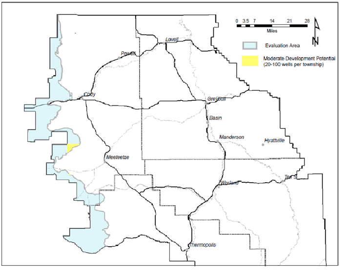 |
Figure Y-1. Absaroka Front Evaluation Area
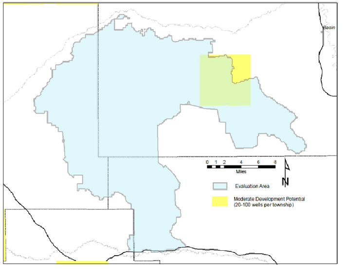 |
Figure Y-2. Fifteen Mile Evaluation Area
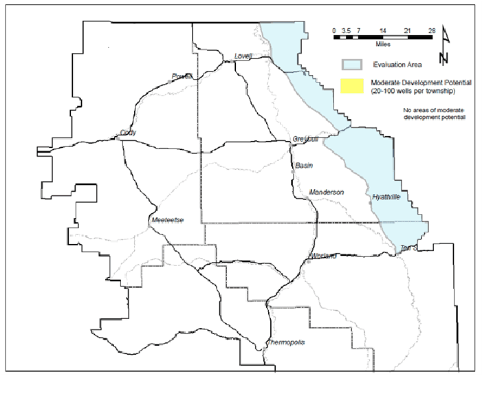 |
Figure Y-3. Big Horn Front Evaluation Area
Table Y.1.
| Topic | Absaroka Front | Fifteen Mile | Big Horn Front |
|---|---|---|---|
| Total Acreage | 402,683 | 243,936 | 445,348 |
| Acres BLM-administered Mineral Estate Minerals | 253,603 | 230,945 | 377,783 |
| Acres Existing Leases (Map 7) | 23,199 | 68,907 | 1,886 |
| Resources of Concern | Wildlife habitat including white tail and mule deer, elk, sheep, mountain goat, Grizzly bears, and wolves | Recreational opportunities, scenic, remote, sagebrush, salt desert habitats, badlands, vertebrate fossils | Wildlife habitat, recreational opportunities, and rare plants |
| Special Recreation Management Area (SRMA) and Recreation Management Zone (RMZ) | |||
| Associated Management Actions | Refer to Chapter 2 Recreation Alternatives beginning with Record # 6073. | ||
| Alternative A Name/acres | Absaroka Foothills SRMA / 46,369 | West Slope / 300,652 | Badlands SRMA / 213,610 |
| Alternative B | Absaroka Foothills / 46,369 | Brokenback/Logging Road / 25,980 | Tatman Mountain RMZ / 46,835 |
| Alternative C | None | None | None |
| Alternative D | Absaroka Mountain Foothills / 26,907 | Brokenback/Logging Road / 49230 | Tatman Mountain RMZ / 46,835 |
| Wilderness Study Areas | Owl Creek/ 668 | Bobcat Draw / 16,943 | Alkali Creek / 9,479 |
| Areas of Critical Environmental Concern | |||
| Associated Management Actions | Refer to Chapter 2 Management Actions beginning with Record # 7000. | ||
| Alternative A | Carter Mountain / 10,947 | None | Brown/Howe Dinosaur / 5,226 |
| Alternative B | Carter Mountain / 22,203 Clark’s Fork Canyon / 14, 056 Rattle Snake Mountain / 21,259 Sheep Mountain / 72,421 Upper Owl Creek / 33,285 | None | Brown/Howe Dinosaur / 20,284 |
| Alternative C | None | None | Brown/Howe Dinosaur / 5,226 |
| Alternative D | Carter Mountain / 10,947 Clark’s Fork Canyon / 2,880 Sheep Mountain / 25,960 Upper Owl Creek / 13,565 | None | Brown/Howe Dinosaur / 5,226 |
Oil and gas constraints within each Evaluation Area vary by alternative (Figures Y-4 to Y-6). The oil and gas constraints are depicted in maps 17-20.
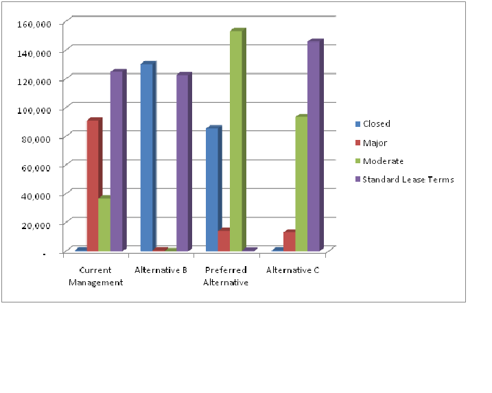 |
Figure Y-4. Absaroka Front Evaluation Area Oil and Gas Constraints by Alternative
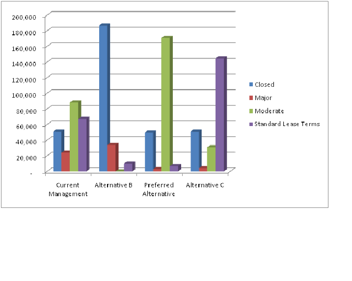 |
Figure Y-5. Fifteen Mile Evaluation Area Oil and Gas Constraints by Alternative
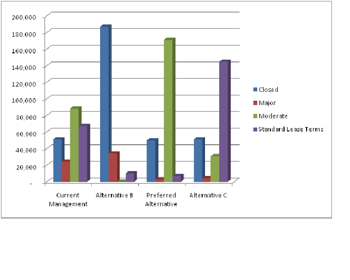 |
Figure Y-6. Big Horn Front Evaluation Area Oil and Gas Constraints by Alternative