M.3 Affected Environment and Environmental Consequences
The following sections describe the environmental consequences that would occur due to hardrock mineral leasing in Alternative
D. There would be no impacts associated with hardrock mineral leasing under Alternative A (No Action Alternative), Alternative
B, or Alternative C. Therefore, these alternatives are not discussed any further.
M.3.1 Assumptions for Analysis
This section describes the assumptions used for analysis of impacts and the level of exploration and development that is reasonably
foreseeable during the life of the plan in Alternative D.
M.3.1.1 Alternative D
The following information is summarized from the Eastern Interior RMP Reasonably Foreseeable Developments for Locatable Minerals and Leasable Hardrock Mineral Resources in
the White Mountains Subunit (BLM 2012b) which is incorporated by reference. In the reasonably foreseeable development scenario (RFD) the BLM developed
models for typical suction dredging, small placer, and large placer operations, describing acres of annual disturbance, size
of the crew, hours of operation, fuel requirements, and type of equipment used for each type of operation. These same models
were used for the analysis of hardrock mineral leasing. This analysis assumes that development under mineral leases would
occur in a similar manner to development under the 3809 regulations (43 CFR 3809).
In accordance with the regulations for hardrock leasing (43 CFR 3500), the BLM envisions the following potential developments:
| 1. | The BLM would offer competitive leases for known deposits of placer gold in areas with high development potential (64,000 acres). |
| 2. | In the areas of known deposits of placer gold with medium development potential (85,000 acres), the BLM could issue exploration licenses based on public interest, likely leading to additional placer leases. |
| 3. | The BLM could issue exploration licenses based on public interest in the Roy Creek known REE deposit (11,000 acres). It is unlikely that any lode mineral occurrences explored under a license would move to a production lease within the anticipated twenty-year life of this plan. |
Methodology for Estimation of Mining Activities
To estimate the types and number of mining-related activities that might occur in the White Mountains if known mineral deposits
were made available for leasing, the BLM compared State of Alaska land of a similar nature in the Steese Subunit. For every
7,000 acres of state land in the Steese, there is one typical placer operation. There is one suction dredge operation for
every six miles of dredgable stream on high development potential areas of the Steese. These ratios are applied to areas of
known mineral deposits in the White Mountains NRA to establish the number of anticipated mechanical placer mining leases,
suction dredge leases, and both REE and placer exploration licenses over the life of this plan (Tables 3.1 and 3.2). Tables
3.1 and 3.2 include only acreage that can be directly estimated. Surface disturbance due to access routes was not estimated.
Access Assumptions
In order to reduce impacts, access would generally be limited as follows:
| • | Helicopter access for exploration licenses in the Roy Creek REE deposit; |
| • | No construction of roads for exploration licenses; |
| • | Winter overland moves for heavy equipment; |
| • | Summer access by all-terrain vehicle (ATV), consistent with off-highway vehicle (OHV) designations for Alternative D (limited to 1,000 pounds curb weight and 50 inches width). The BLM could approve heavier vehicles, such as utility terrain vehicles (UTV), on a case-by-case basis. The BLM would determine access routes to mining locations off current BLM-managed recreational trails on a case-by-case basis. Seasonal restrictions may apply; |
| • | Aircraft (helicopter or fixed-wing); and, |
| • | The BLM could consider construction of new access roads for placer development on a case-by-case basis if consistent with recreation management objectives and if other access was not feasible. The BLM estimates up to 20 miles of roads could be built over the life of the plan. |
Leases
The BLM may issue a competitive lease on unleased lands where a known valuable mineral deposit exists. This lease is accomplished
through a competitive lease sale. There are two types of leases applicable to hardrock mining in the White Mountains NRA,
and they are described in more detail below.
Suction Dredge Placer Leases: In addition to the mechanical operations described below, the BLM estimates there would be 10 suction dredge operations on
lands with high placer development potential and one additional operation on lands with medium development potential. A suction
dredge operation is limited to within active steam margins and would disturb about one-half acre per year. The maximum potential
disturbance from all 11 operations for the twenty-year life of the plan with natural concurrent reclamation is 84 acres.
Mechanized Placer Leases: To estimate the effects of development of traditional placer mining operations, the BLM considered two mining models: a smaller
mobile placer operation using a small dozer and excavator feeding an 11 cubic yard-per-hour washplant and a larger 145 cubic
yard-per-hour “Kantishna-type” washplant supported by a larger excavator and track-dozer. A small operation would mine and
reclaim one acre per year, but have a continual 4.4 acres of disturbance per year for a total disturbance of 27 acres for
the life of this plan. A large operation would have a continual 20 acres of disturbance and a total disturbance of 107 acres
over the life of this plan. The BLM estimates there could initially be two large and eight small operations annually, with
an additional three small operations following work done under exploration licenses, for a total disturbance of 507 acres
over the life of the plan.
Exploration Licenses
An exploration license allows the applicant to explore known mineral deposits to obtain geologic, environmental, and other
pertinent data concerning the deposits. The application for an exploration license includes an exploration plan approved by
the BLM that becomes part of the license. The requirements for an exploration plan are described in 43 CFR 3505.45. A proposed
notice of exploration must be published, inviting others to participate in the exploration under the license on a pro-rata
basis. Applications for exploration licenses would be subject to site-specific analysis under the National Environmental Policy
Act (NEPA). Site-specific measures to protect the environment and use for recreation would be included in the approved exploration
license. There are two types of licenses applicable to hardrock mining in the White Mountains NRA, and they are described
in more detail below.
Placer Exploration Licenses: The BLM may require exploration of placer resources in the medium development potential areas prior to issuing placer leases;
the applicant may request exploration licenses in the higher development potential areas before the BLM offers competitive
leases. Most placer exploration would cause minimal disturbance, but the applicant could also request approval for more intensive
placer sampling with heavy equipment. The BLM anticipates there could be four exploration licenses (5,000 acres each) requested
within the lands opened to leasing, resulting in direct disturbance to and reclamation of 20 acres over the life of the plan.
Rare-Earth Element Exploration Licenses: If the White Mountains NRA were opened to hardrock leasing, there would likely be an exploration license request for the
11,000 acres in the Roy Creek REE known deposit. Exploration activities would range from field mapping and sampling, to trenching
and core-drilling. The total life-of-plan disturbance from exploration of the Roy Creek REE deposit is expected to be 50 acres.
Anticipated Activity Due to Hardrock Leasing in the White Mountains Under Alternative D
| Activities under Reasonably Foreseeable Exploration and Development | High Potential Lands – Gold | High Potential Lands - REE | Medium Potential Lands – Gold | Total |
|---|---|---|---|---|
| # Suction dredge placer leases | 10 leases | 1 lease | 11 | |
| Life of plan disturbance due to suction dredging (active stream channel only) | 76 acres | 7.6 acres | 84 acres | |
| # Mechanized placer leases | 2-large leases 8-small leases |
3- small leases | 13 leases | |
| Life of plan disturbance due to mechanized placer mining (uplands/floodplains) | 427 acres | 80 acres | 507 acres | |
| Total lease disturbance (20 years) | 503 acres | 88 acres | 591 acres | |
| Acres open to leasing | 64,000 acres | 11,000 acres 161 | 85,000 acres | 160,000 acres |
Anticipated Activity Associated with Exploration Licenses in the White Mountains Under Alternative D
| Activities under Reasonably Foreseeable Exploration and Development | High Potential Lands Lode REE | Medium Potential Lands – Placer Gold | Total |
|---|---|---|---|
| # Placer exploration licenses | 4 | 4 | |
| Area licensed for placer (acres) | 20,000 | 20,000 | |
| Acres of disturbance due to placer exploration licenses | 20 | 20 | |
| # Lode exploration licenses | 1 | 1 | |
| Area licensed (acres) | 11,000 | 11,000 | |
| Acres of disturbance due to lode exploration licenses | 50 | 50 | |
| Total disturbance from exploration licenses (20 years) | 50 acres | 20 acres | 70 acres |
M.3.2 Affected Resources
M.3.2.1 Cultural and Paleontological Resources
Affected Environment
Placer gold prospecting and mining has occurred in some drainages in the White Mountains NRA for more than 100 years. The
specific areas outlined in Alternative D equate to areas of known historic mineral activity. Non-systematic archaeological
surveys in these areas have found historic mining sites immediately adjacent to portions of all creeks addressed in this alternative.
Similarly, Alaska Native prehistoric sites have been found along two of the creeks in this alternative, in spite of the almost
complete lack of archaeological surveys aimed towards finding such sites in the project area. There are almost certainly more
such sites.
Environmental Consequences
Section M.3.1 of this appendix describes the nature of the proposed hardrock mineral leasing. Alternative D outlines disturbance
of up to: 507 acres by mechanized placer mining operations, 70 acres from the issuance of exploration licenses, and 84 acres
by suction dredging in and alongside specified creeks (including Ophir, Bear, Trail, Quartz, Champion, and Little Champion
creeks).
Surface disturbing activities, including mining and exploration activities outlined here, directly and adversely impact cultural
and paleontological resources. Disturbance to prehistoric sites by any particular mining or exploration operation would need
to be assessed on a case-by-case basis. Their locales on the landscape are a bit more predictable than are historic mining
sites. In sum, hardrock mineral leasing would likely directly and adversely impact all manner of surface and buried cultural
and paleontological resources.
Similarly, new access roads might be authorized to reach future valid mineral leases. New road construction has a direct and
adverse effect on cultural and paleontological resources. It also has an indirect effect when new users (such as recreators,
hunters, and those interested in procuring forest and woodland products) gain access to previously isolated lands. With more
resource users accessing BLM-managed lands, the potential increases for more people finding surface cultural resources and
adversely impacting them, whether intentional or not.
Cumulative Effects
Cumulative impacts to cultural and paleontological resources can occur through incremental degradation of the overall resource
base. Excepting especially rare or unique sites, the destruction of any one, two, three, or more sites would likely not impact
the overall, areal resource base, as there would probably be more of any similar type of site elsewhere in the planning area.
However, cultural and paleontological resources are a non-renewable resource and the loss of any one of them is one less from
a finite total. There would eventually be a point at which the cumulative overall destruction of sites would limit management
options within any defined area, such as the planning area. Hardrock mineral leasing in the White Mountains would contribute
to this cumulative effect.
Many low-level, seemingly minor impacts (such as walking or camping on a site) can slowly and cumulatively grow into a larger
direct adverse effect over time. Similarly, visitors to sites often feel an urge to connect with the past by removing a piece
of the site when they leave, like an artifact. Removal of a one, two, three, or more artifacts would not likely affect overall
site interpretation. However, the point would come when enough artifacts are removed, that the cumulative removal would irreversibly
affect any interpretations that can be made about that site. By promoting and increasing use and visitation upon public lands,
hardrock mineral leasing may inadvertently adversely impact cultural and paleontological sites in this cumulative manner.
M.3.2.2 Fish and Aquatic Species
Methods of Analysis
Indicators: For aquatic resources, fish, and Special Status Species, the indicators used to identify the level of impact include water
quality, riparian vegetation, streambank stability, and stream miles open to leasing of hardrock minerals.
Methods and Assumptions: Potential impacts on fish and aquatic resources are based on interdisciplinary team knowledge of the resources and the planning
area. Impacts were identified using best professional judgement and were assessed according to the following assumptions:
| • | Healthy riparian areas are critical for properly functioning aquatic ecosystems. Improvements or protection of riparian habitats would indirectly improve or protect aquatic habitats and fisheries. Adverse impacts to riparian habitats would indirectly degrade aquatic habitats and fisheries; |
| • | All of the anadromous streams or extent of anadromy within the area proposed for hardrock mineral leasing may not yet be identified; |
| • | A hardrock mineral leasing program would result in an increased number of placer mining operations with the potential to adversely affect fish and aquatic resources, including BLM Alaska watch list species and the outstandingly remarkable fisheries value for Beaver Creek; |
| • | All BLM land use authorizations would incorporate appropriate project design, Procedures, and mitigation to ensure no adverse long-term (greater than 20 years) impacts to water quality and aquatic habitats exist. |
| • | The BLM would identify channel reconstruction activities. Reconstructed stream channels would be designed by an individual(s) trained and qualified for the task and the channel would be built as designed. |
| • | Reclamation techniques would use an “adaptive management” approach to address potential problems allowing for corrective actions should they become necessary. These techniques would ensure applicable performance standards and required conditions are met at the conclusion of operations. |
| • | The timeframes associated with long- and short-term impacts assume that channel equilibrium is maintained. |
Affected Environment
A general description of fish and fish habitat within the planning area, including areas specific to Alternative D, is in
section 3.2.4.1 of the Eastern Interior Draft RMP/EIS (BLM 2012a) and is incorporated by reference. The planning area supports
17 native fish species. None of these species are listed as threatened or endangered. With few exceptions, the current condition
of fish species is good, and most fish populations are self-sustaining.
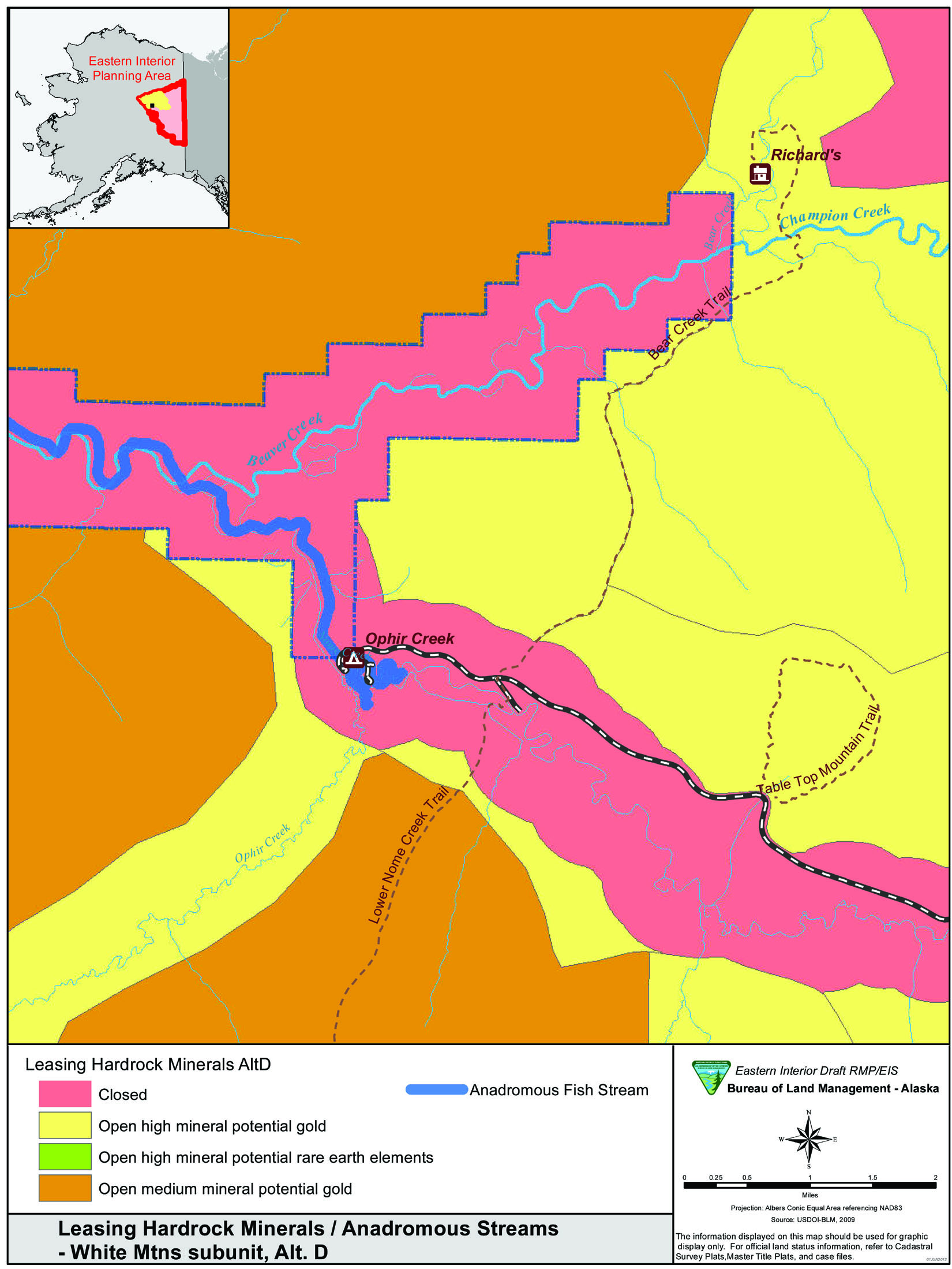
Approximately 160,000 acres are recommended open to hardrock mineral leasing in Alternative D, including 250 miles of headwater
streams located in the southeast portion of the White Mountains NRA. These streams form the headwaters of Beaver Creek WSR
(Figure M.1). These headwater streams are clear, rapid streams with long riffles, few pools, with an average width of 50 feet
(Rhine 2005). The substrate generally consists of a gravel-cobble mixture (3 to 12 inches in diameter). Although some placer
mining activity has occurred in headwater areas of Beaver Creek, most of these streams are thought to be in pristine condition,
with the exception of Nome Creek. Nome Creek was heavily placer mined for gold from the early 1900s to the late 1980s. Mining
disturbed more than seven miles of stream and by the 1980s the floodplain was largely obliterated (Kostohrys 2007). From 1991
to the present, the BLM has been working to restore the floodplain, reestablish riparian vegetation, and maintain a single
thread channel. The BLM has expended an estimated $450,000 on the Nome Creek reclamation project (USKH 2006).
Fish species found within the upper Beaver Creek watershed that are adjacent to or within areas recommended open to mining
include Chinook salmon (Oncorhynchus tshawytscha), Arctic grayling (Thymallus arcticus), whitefish (Coregoninae spp.), and slimy sculpin (Cottus cognatus). Beaver Creek also supports regionally significant fish species which include small populations of coho (O. kisutch), and summer chum salmon (O. keta). The creek also supports moderate to high densities of Arctic grayling and northern pike (Esox lucius) which provide important recreational fishing opportunities. These populations of regionally significant fish species, unique
concentrations of Arctic grayling, and the river’s pristine habitat support BLM’s identification of fish as an Outstanding
Remarkable Value (ORV) for Beaver Creek (BLM 2012a, Appendix E).
The BLM monitored Beaver Creek Chinook salmon escapement from 1996 to 2000 and the data revealed a declining trend similar
to the overall decline of Yukon River Chinook salmon (Volk et al. 2009). The Beaver Creek Chinook salmon escapement for these
years ranged from 114 to 315 Chinook salmon. Although Beaver Creek Chinook salmon were designated as a BLM Alaska sensitive
species in 2004 due to the downward trend of this small population, they were recently removed from that list and placed on
a watch list. Since 2000, the Alaska Department of Fish & Game (ADF&G) has considered the Yukon River Chinook salmon stock
as a stock of yield concern based on escapement performance, expected yields, and harvestable surpluses (Howard et. al. 2009). Beaver Creek Chinook are
a component of the Yukon stock. Between 1996 and 2000, the overall Yukon River Chinook escapement range from the highest (about
300,000) to the lowest (about 100,000) dating back to 1982. Beaver Creek contributes a small percentage of the overall Yukon
River Chinook salmon stock. The Yukon stock, however, is made up of numerous genetic stocks (such as the Beaver Creek stock)
all of which are considered important to the overall health and viability of the stock.
The ADF&G Anadromous Water Catalog identifies Chinook salmon spawning and rearing in Beaver and Ophir creeks and Chinook
spawning in Nome Creek (Figure M.2). Adult Chinook salmon in spawning condition have been observed at the confluence of Bear
and Champion Creek (E. Yeager, pers. comm. May 15, 2012). That location is many miles farther upstream than what the Anadromous
Waters Catalog identifies as the extent of anadromy. This reinforces ADF&G’s assumption that approximately 50 percent of the
anadromous streams or extent of anadromy have not yet been identified.
Map of Anadromous Streams in Headwaters of Beaver Creek
The excellent opportunity for Arctic grayling fishing was one of the values identified for establishing Beaver Creek as a
component of the National Wild and Scenic Rivers System (BLM 1983). In 2000, the BLM and ADF&G performed an Arctic grayling
study on the upper 30 miles of Beaver Creek, including the area between the confluence of Bear and Champion creeks and the
confluence of Nome Creek (Fleming et al. 2001). This study estimated the population density of Arctic grayling at 1,325 per
mile, which is higher than other studies on summer feeding populations in Alaska by as much as 44 percent. The study also
revealed an increase in the size of grayling as the study moved upstream to the headwaters of Beaver Creek. This pattern was
reinforced by other studies that found large male Arctic grayling migrating from downstream areas to Bear and Champion creeks
during late May and June, while females and smaller males move into these areas during July and August (Rhine 1985). Within
the upper 100 miles of Beaver Creek, the headwater streams (e.g., Bear and Champion creeks) have produced the largest and
oldest Arctic grayling based on BLM and ADF&G fish sampling efforts and reports from recreational anglers (T. Dupont, pers.
comm., May 22, 2012). This pattern reflects the generally accepted life-history paradigm for Arctic grayling that larger and
older fish spend the summer feeding period in headwater areas and tributaries of rapid runoff rivers in Alaska (Armstrong
1982). Although Arctic grayling primarily use the headwater streams for summer feeding, some evidence of spawning has been
observed (Rhine 1985; Kretsinger 1986) and may justify future inventory work.
Environmental Consequences
The effects on fish and aquatic habitats of mining (and exploration) for hardrock minerals in the White Mountains Subunit
under mineral leases would be similar to those described for locatable mineral development in other parts of the planning
area. These effects are described in section 4.3.1.4 of the Eastern Interior Draft RMP/EIS (BLM 2012a) and are incorporated
by reference.
Suction dredging, a type of placer mining, can have both beneficial and adverse effects on fish and aquatic habitat depending
on the timing and location of the activity.
Suction dredging has been shown to locally reduce benthic (bottom dwelling) invertebrates (Thomas 1985; Harvey 1986), cause
mortality to early life stages of fish due to entrainment by the dredging equipment (Griffith and Andrews 1981), destabilize
spawning and incubation habitat, remove large roughness elements such as boulders and woody debris that are important for
forming pool habitat and that can govern the location and deposition of spawning gravels (Harvey and Lisle 1998), increase
suspended sediment, decrease the feeding efficiency of sight-feeding fish (Barrett et al. 1992), and reduce living space by
depositing fine sediment (Harvey 1986).
Conversely, suction dredging may temporarily improve fish habitat by creating deep pools or by creating more living space
by stacking large non-embedded substrate (Harvey and Lisle 1998; Figure M.2). In dredged areas, invertebrates and periphyton
are known to recolonize relatively rapidly, as long as the disturbance area is sufficiently limited to maintain populations
of recolonizing organisms (Griffith and Andrews 1981; Thomas 1985; Harvey 1986). In addition, dredge tailings may increase
spawning sites in streams lacking spawning gravel or streams that are armored by substrate too large to be moved by fish (Kondolf
et al. 1991). In some cases, reduced visibility caused by elevated levels of turbidity can diminish the feeding efficiency
of fish, while at the same time the reduced visibility may lessen the risk of predation (Gregory 1993).
Suction dredging operations within the Steese Subunit have been known to adversely impact streambank stability as well as
riparian and stream channel function. Although disturbance to streambank and riparian habitats and alterations to the stream
course is prohibited for suction dredging operations, in some cases these areas have been impacted. This type of activity
results in an overwidened and shallow stream course, which is braided around stacked piles of large substrate. These impacts
adversely affect riparian and stream function and if not reclaimed may persist for extended periods of time (years/decades)
due to the amount of stream energy required to redistribute this large-sized substrate in the stream channel. It is assumed
that these situations would be limited and that lease and license stipulations would minimize the level and duration of impacts
to aquatic resources.
The anticipated number of suction dredging operations during the life of this plan is 11 (Table M.3). There would be 250 miles of stream open mineral leasing with an anticipated disturbance of 84 acres, or 14 miles of stream.
Suction dredging operations are anticipated to disturb 22,000 cubic yards of stream gravel over the life of this plan or the
equivalent of 2,200 typical (10 cubic yard) dump truck loads of stream gravel. Impacts from suction dredging operations that
do not alter streambank stability or adversely impact riparian and stream channel function, and adhere to stipulations in
the suction dredge permit, are likely to be minimal and of short-term duration (less than or equal to five years).
Mechanized Placer Leases – Conventional Mining
For Alternative D, fish and aquatic resources would be primarily affected by surface-disturbing activities which alter stream
channels and floodplain connectivity, remove or impair riparian vegetation and function, or result in soil erosion and sedimentation
to fish and aquatic habitat. These activities would include mechanized placer mining and associated road construction that
occur within or adjacent to riparian areas or waterbodies.
Conventional mechanized placer mining involves the use of heavy equipment to access gold deposits. One method of mine development
is to move the stream into a bypass channel, while the original stream channel is excavated for gold deposits. During this
process the streambed, streambanks, and riparian vegetation are physically removed in order to access gold-bearing fluvial
deposits which may extend to the bedrock. This method destroys the existing fish and aquatic habitat and eliminates all biological
stream functions. Impacts to fish and aquatic resources can be severe and last for decades under the stream-altering bypass
method (Tidwell et al. 2000, Arnett 2005, Viereck et al. 1993; Milner and Piorkowski 2004; BLM 1988 a, b, and c). Soil erosion
from large surface disturbing activities (such as mechanized mining) often results in poor water quality and elevated turbidity
levels harmful to fish and fish habitat far beyond the impact site. The River Management Plan for Beaver Creek National Wild
River (BLM 1983c) stated that placer mining activities in the headwaters of Beaver Creek resulted in turbid water conditions
as far as 30 miles downstream. Surface management regulations have since changed, in part to reduce adverse impacts to water
quality from mining. The severity and duration of impacts are substantially reduced when mining operations occur outside of
the stream channel and active floodplain.
The anticipated number of mechanized placer mining leases during the 20-year life of this plan is 13 (BLM 2012b). Approximately
250 miles of stream would be open to leasing for mechanized placer mining with an anticipated amount of disturbance of 507
acres. This disturbance would likely occur within floodplain areas and/or in the stream channel. In an attempt to quantify
the number of stream miles that may be directly impacted by leasing, the length of a typical mining claim block (660 feet)
from other subunits was used. The anticipated number of stream miles directly impacted by leasing would be eight miles. The
likelihood of impacts would be greatest in the high development potential areas, which, contain more than half of the stream
miles open to mechanized leasing.
If mining did occur, the ROPs specific to fish and aquatic species (Appendix A) would improve the likelihood of obtaining
desired future conditions for aquatic habitats within an accelerated timeframe after reclamation. A range of success would
be expected based on several factors. These factors include baseline data collection, stream channel design/construction technique,
the reclamation measures specified for the particular operation, the watershed characteristics, the capability of the site
to revegetate, and the probability of experiencing a flood event prior to the reestablishment of riparian vegetation that
is capable of dissipating stream energy and preventing erosion.
Assuming that baseline data is collected, reclamation is designed using the best available techniques such as those outlined
in the Natural Resources Conservation Service’s (NRCS, 2007) Stream Restoration Design, National Engineering Handbook, Part 654, and all of the factors previously mentioned are favorable, it is likely that instream habitats would rehabilitate within
five years following reclamation. In these cases, impacts would be expected to be minor and short-term. However, stream channel
design/reconstruction and aquatic habitat rehabilitation is very complex, especially within the planning area due to the harsh
environmental conditions (such as short growing season, aufeis) and limited availability of hydrography data. Recognizing
this complexity, a more realistic outcome may be a strong positive trend toward the desired habitat conditions within five
to ten years under this management scenario. It would be essential that reclamation plans incorporate stream channel design
based on channel forming discharge (typically a 1.5 year recurrence interval) and the floodplain be capable of transporting
100-year flood flows. This would minimize the chance of reclamation failure and the need for subsequent reclamation work by
the operator.
In summary, placer mining can negatively affect fish and aquatic resources by degrading or eliminating aquatic habitat; reducing
available food sources and water quality; reducing available pool habitat; eliminating riparian vegetation and function; creating
sparsely vegetated valleys and floodplains with slow rates of natural revegetation and unstable stream channels with highly
erodable beds and banks; altering the longitudinal slope, geometry, and sediment transport rates in streams; and, creating
undersized or absent floodplains.
Mineral Exploration Licenses
It is anticipated that there would be four placer exploration licenses and one lode exploration license. Placer exploration
licenses may encompass 20,000 acres with an anticipated disturbance and reclamation of 20 acres over the 20-year life of this
plan. The impacts to fish and aquatic resources would vary depending on the location, type of exploration activities, and
subsequent reclamation, all of which would be analyzed during a site-specific NEPA analysis prior to approval of exploration
licenses and exploration plans.
Potential adverse impacts would likely be from surface erosion of disturbed soils and the destruction of riparian vegetation
resulting in elevated turbidity levels and sedimentation to nearby water bodies. The effects of excess sediment and the removal
of riparian vegetation to fish and aquatic resources is described in section 4.3.1.4.1 of the Eastern Interior Draft RMP/EIS,
which is incorporated by reference. Although sediment is a natural part of the aquatic ecosystem, an increase in fine sediment
has the potential to affect the availability of food, predator avoidance, immune system heath, and reproduction of fish and
aquatic species. The ROPs (Appendix A) should reduce impacts from exploration to a negligible level with short duration given
the anticipated level of disturbance from exploration activities. The larger the surface disturbance and the closer it is
to the stream, the greater the severity and duration of the impact.
It is anticipated that one lode exploration license would be requested in the Roy Creek REE deposit, resulting in 50 acres
of disturbance. While it is unlikely that fish or fish habitat studies have ever been performed in the headwaters of Roy Creek,
it is reasonable to conclude that fish may not be present in the headwaters of this relatively small, high gradient stream.
Direct impacts from lode exploration are not anticipated. Potential indirect adverse impacts from surface erosion would be
similar to those described above for placer exploration activities.
Previous surveys in the Roy Creek area indicate that the soils are mainly of the granitic type (John Hoppe, pers. comm. May
10, 2012) that pose little threat to fish and aquatic life when disturbed and exposed to air and water. Although unlikely,
if soils containing sulfide bearing ore were disturbed and exposed to air and water during exploration activities, acid mine
drainage may occur and result in adverse indirect impacts to downstream waters. Acid mine drainage can cause physical, chemical,
and biological degradation to aquatic habitat (Jennings et al. 2008). Predicting the risk of acid mine drainage at mine sites
is often inaccurate (Jennings et al. 2008). It will be necessary to collect site-specific information variables and data to
predict the potential for acid mine drainage in the Roy Creek area.
Outstandingly Remarkable Values and Watch List Species
As noted previously, the Arctic grayling fishery was one of the values identified when Beaver Creek was established as a component
of the National Wild and Scenic Rivers System (BLM 1983c). Fish are currently proposed as an outstandingly remarkable value
for Beaver Creek (BLM 2012a, Appendix E). As such, fish habitat within Beaver Creek and its tributaries in the White Mountains
NRA have been managed to maintain and/or enhance fish populations with an emphasis on Arctic grayling (BLM 1986). Similarly,
a major goal for the NRA is to protect and maintain the water quality of Beaver Creek to meet state water quality standards
and promote a quality fishing experience (BLM 1986b). Mechanized placer mining within the floodplain and/or stream channels
of Beaver Creek’s principal tributaries would not maintain or enhance fish habitat and populations or water quality. The White
Mountains NRA Record of Decision and Resource Management Plan (BLM 1986b) states that “Extensive placer mining on Beaver Creek
or its principal tributaries would be in conflict with recreational purposes because of degradation to natural and primitive
values of the Beaver Creek WSR corridor and damage to Arctic grayling habitat”. It also states that sport fishing on Beaver
Creek contributes to public enjoyment of the NRA and fish habitat in tributary streams should be protected because they contribute
to fish populations in Beaver Creek.
Beaver Creek Chinook salmon are currently a BLM Watch List species (BLM 2010). This species should be emphasized for additional
inventory, monitoring, or research efforts to better understand the population or habitat trends. Beaver Creek Chinook salmon
are a component of the Yukon River Chinook stock, a stock of yield concern since 2000 (Howard et al. 2009). Beaver Creek Chinook salmon spawn and rear immediately downstream and potentially within
the area proposed for opening to conventional mining (Figure M.1). The adverse impacts from mechanized mining, including the
downstream effects and habitat degradation, could cause the Beaver Creek Chinook to become designated as a BLM Alaska Sensitive
Species.
Cumulative Effects
Cumulative impacts to fish and aquatic resources consist of past, present, and reasonably foreseeable future impacts, including
impacts on non BLM-managed lands. Hardrock mineral leasing in Alternative D would add to cumulative impacts from exploration
and development of locatable and leasable minerals elsewhere in planning area, including on state and private lands.
Fish and aquatic resources have been adversely impacted from past mechanized mining activity in the Beaver Creek drainage.
The majority of these impacts occurred from 1900 until the mid-1980s in Nome Creek, where extensive mining for placer gold
obliterated seven miles of stream and floodplain (Kostorhys 2007). This activity resulted in the direct loss of fish habitat
and sediment pollution to Beaver Creek. Although habitat conditions in Nome Creek have greatly improved from nearly 20 years
of reclamation work by the BLM, desired conditions for aquatic habitat have not yet been achieved (desired future conditions
are described in section 2.4.1.3 of the Draft RMP/EIS, BLM 2012a). Portions of Nome Creek have not been reclaimed and are
not likely to be in desired condition for aquatic habitats. Mechanized mining activities have also occurred in other tributaries,
but to a much lesser extent. There are no known current mining activities in the Beaver Creek drainage.
A hardrock mineral leasing program would open 160,000 acres to the leasing and exploration of formally locatable minerals
in the White Mountains NRA with an anticipated disturbance of 661 acres and eight miles of stream. Suction dredging activities
may impact 14 miles of stream. Past and future mechanized mining proposed in this alternative may result in approximately
20 miles of stream within the NRA that would not meet the desired conditions for aquatic habitats. Cumulative impacts specific
to the NRA would be in addition to the cumulative impacts described in section 4.3.1.4.2. of the Eastern Interior Draft RMP/EIS
(BLM 2012a). Cumulative impacts from Alternative D, would have the greatest potential for adverse impacts to fish and aquatic
resources relative to the other alternatives.
M.3.2.3 Non-Native Invasive Species
Alternative D also allows the most latitude to OHV use and rights-of-way and would result in the greatest disturbance to soil
and vegetation in the areas recommended open to hardrock mineral leasing. This would create the greatest potential for the
introduction of nonnative invasive plant species (invasive plants) within the White Mountains NRA. Equipment imported for
mineral exploration and development activities often harbor seeds of invasive species that could dislodge and germinate at
these remote sites.
The reasonable foreseeable development scenario (RFD) forms the basis for evaluating the impacts to resources (section M.3.1)
from hardrock mineral leasing. The total disturbance over the life of the plan is expected to be 661 acres from all hardrock
leasing and exploration licenses, a relatively small portion of the 160,000 acres open to exploration and development. Assuming
that exploration and development occurs throughout the open area, invasive plant species could be introduced in a dispersed
rather than concentrated pattern, complicating control and containment.
The RFD includes the assumption that 20 miles of roads would be built in support of new placer developments. The roads are
linear vectors for the introduction and spread of invasive plants into these remote areas. Seeds from infestations along roads
can move along other intersecting linear features, such as trails and waterways, further spreading undesirable nonnative species
into remote areas. For example, infestations of white sweetclover (Meliotus officianalis) have been documented on sand bars along the Nenana River, spreading from source populations upstream (Conn et al. 2008).
Section 4.7.1.3.4 of the Eastern Interior Draft RMP/EIS (BLM 2012a), which is incorporated by reference, contains analysis
of rights-of way development in the White Mountains NRA for Alternative C. Impacts identified in this section apply to the
roads in support of new placer developments analyzed in this supplement.
Any natural or human-caused disturbance to the landscape provides an opportunity for invasive plants to become established.
Equipment, watercraft, vehicles, and gear may harbor seeds that may then be transported to project sites. Climate change may
accelerate the ability for invasive plants to become established (Rupp and Springsteen 2009). More general information about
vectors and impacts from introduction and spread of nonnative invasive plants are in Chapter 4 of the Eastern Interior Draft
RMP/EIS (BLM 2012a). This information is incorporated by reference. Section 4.3.1.5 discusses effects common to all subunits.
Section 4.7.1.3 of the Draft RMP/EIS contains analysis of impacts for locatable minerals on 4,000 acres of valid existing
rights outside the NRA and other decisions, but assumes no hardrock leasing within the White Mountains NRA. Impacts from hardrock
mineral leasing would be similar to those from locatable mineral exploration and development.
ROPs and Leasing Stipulations in Appendix A of the draft RMP/EIS and those modified in this supplement (shown in Appendix
A of this document) to mitigate impacts from hardrock mineral leasing would be applied on a case-by-case basis to leases and
exploration licenses. ROPs in section M.4.2.10 of this document specifically address eliminating or minimizing the introduction
and spread of invasive plants by prescribing standards for vegetation treatment, revegetation with native plants, reclamation
for roads and trails, and salvage of vegetative mat and topsoil. Other ROPs in Appendix A would also help limit the introduction
and spread of invasive plants.
Nonnative invasive species other than plants may be introduced by exploration or development when equipment from Canada or
other parts of the United States are imported to the work sites. This equipment can harbor insect eggs, larvae, pupae, adult
or other viable life cycle stages and other undesirable pathogens and pests. Little documentation exists that invasive species
other than plants have been introduced into Interior Alaska. Over the life of the plan where there may be concerns about other
invasive species, however, permit stipulations to mitigate introduction of insects, other pests and pathogens would be developed
on a case-by-case basis.
Indirect impacts would result where invasive plants become established due to hardrock exploration development, including
potentially long-term changes in plant community structure and diversity and wildlife habitat degradation. Costs include long-term
monitoring and control. Containment and control of invasive plants for the long-term may also include further soil disturbance
and the application of herbicides.
Cumulative Effects
Cumulative effects of past, present and reasonably foreseeable actions that are common to all for nonnative invasive species
have been developed in section 4.3.1.5.2 of the Eastern Interior Draft RMP/EIS (BLM 2012a). Cumulative effects specific to
the White Mountains Subunit for nonnative invasive species are in section 4.7.1.3.6. The combination of the removal of vegetation
for exploration and development, increased disturbance of riparian vegetation and bank stability from multiple stream crossings,
user-created trails, new support roads in the southeast portion of the White Mountains NRA, and present and potential future
actions on adjacent federal, state and private lands increases the footprint for invasive plants to become established and
spread from adjacent development into the relatively weed-free NRA. Ongoing climate change is expected to result in an increase
in the number of nonnative species that can become established in subarctic areas due to longer frost-free season and thawing
of permafrost. Changes in precipitation projected for the Eastern Interior may also benefit invasion by invasive plants that
outcompete native plants and alter wildlife habitat.
M.3.2.4 Soil and Water Resources
Compared to other alternatives, Alternative D would result in the greatest disturbance to soil resources and adverse impacts
to water quality because selected areas (Figure M.1) would be open to hardrock mineral leasing. Ongoing climate change would
also affect these resources and may increase the magnitude of effects from mining.
Anticipated disturbance in the White Mountains NRA is estimated at 507 acres by mechanized placer mining operations, 20 acres
associated with the issuance of placer exploration licenses, 50 acres from the issuance of rare earth element exploration
licenses, and 84 acres of disturbance from placer gold suction dredging in areas with high placer gold potential, including
Ophir, Bear, Quartz, Champion, Little Champion and Moose creeks. Mining activities would be limited to approximately 160,000
acres in areas of known historic mineral activity in the south/southeast part of the White Mountains NRA. Lands within one-half
mile of Nome Creek would be closed to leasing because of long-term ongoing stream reclamation as well as parcels of wetland
acreage committed in perpetuity as U.S. Army Corps of Engineers compensatory wetland mitigation acreage.
Disturbance to soil and water resources by any particular mining or exploration operation would need to be assessed on a case-by-case
basis. Impacts to soil and water resources vary depending on the development methods used, size of the operation, and number
of mines. Because 160,000 acres would be open to mineral development under Alternative D there would be increased potential
for adverse impacts to soil and water resources. Impacts would be reduced through application of ROPs and site-specific analysis
of subsequent authorizations.
Effects from Mechanized Placer
Probable impacts to soil and water resources from placer mining were described in detail in the Beaver Creek Placer Mining
Final Cumulative EIS (BLM 1988b). Impacts can vary considerably depending on factors including site characteristics, size
of the disturbed area, and mining methods. Where placer mining operations utilize heavy equipment, the following impacts could
be expected.
Placer mining can have an adverse effect on the existing soil profile structure by stripping of overburden and riparian/wetland
vegetation. The usual procedure is for the overburden (including organic materials) to be stripped, coarse underlying materials
separated from gold-bearing material in the processing plant, and fine materials discharged to a series of settling ponds
with recycled water used by the processing plant. There is an irretrievable loss of any soil that enters waterways and is
transported downstream.
Erosion of soils from non-point sources typically contribute to the sediment load of stream systems and may result from stream
crossings, roadways directly adjacent to stream channels, improved roads and trails which converge down-gradient to stream
channels.
The primary impact to water quality from mining is an increase in sedimentation and turbidity. Some direct effects on water
quality can be anticipated during the development stage of an operation due to the construction of settling ponds and stream
bypasses, and through re-channelization of the stream. This would result in short-term increases in sediment levels and turbidity
while equipment operates near or in the active stream channel.
Leasees would be required to meet Alaska Department of Environmental Conservation water quality standards and acceptable discharge
standards available online at http:\\dec.alaska.gov/commish/regulations/index.htm. It is anticipated that turbidity as a result
of direct and indirect discharge from placer mine operations would meet ADEC water quality standards. However, it is likely
that occasional high water or failure of water control structures would introduce sediments collected by the water treatment
system into the stream channel. This would result in short-term increases in turbidity and sediment load levels and possible
localized sedimentation of the stream substrate. The degree of impact would depend on the amount of material released and
the streamflow at the time of release.
Stream channel morphology would be directly affected in all areas where activities associated with mining occur in the active
channel; by-pass channels are usually constructed to allow mining in the active channel.
Indirect impacts to water quality would occur through non-point source erosion from disturbed areas associated with placer
operations including access road and trails and equipment staging areas directly adjacent to stream channels. Channel readjustment
would occur where the active channel was modified. These processes increase suspended sediment into the stream system, particularly
during spring break-up and floods.
The impacts to soil and water resources could be expected to decrease after cessation of mining, successful revegetation of
the disturbed areas, and stabilization of the disturbed channel. It is estimated that reestablishing vegetation on placer
waste rock piles may take decades. The rate of succession (revegetation) seems to be heavily influenced by the proportions
of particles of silt and clay size in the surface layer of the tailings (Rutherford and Meyer 1981).
ROPs (Appendix A) have been developed to reduce impacts to soil and water resources that may result from hardrock mineral
leasing activities. Additional mitigation measures, if necessary, could be developed during NEPA analysis of specific mineral
leases or exploration licenses. Water quality monitoring requirements (Wagner et al. 2006) would be defined through this process.
Daily stream flow and water quality is currently monitored on lower Nome Creek and on Beaver Creek near its confluence with
Victoria Creek to document daily, annual, and long-term variation in flows and water quality. The BLM would continue to monitor
water quality and in-stream flow in selected streams and lakes to ensure that state water quality standards were met and to
document changes in stream flow. Activities expected to adversely alter natural flows would not be permitted.
Effects from Suction Dredging
Suction dredge mining activities have the potential to affect soil and water resources, particularly if operations require
access over steep terrain or permafrost soils where surface disturbance may result in increased erosion. Adverse impacts could
result from equipment transport and storage, fuel spills, unauthorized expansion of existing trail networks, as well as from
compaction of soils at long-term camping sites associated with suction dredge mining operations.
In Interior Alaska a majority of the suction dredge operations occur in the Fortymile River area. The USGS conducted a systematic
water quality study of the Fortymile River and many of its major tributaries in June of 1997 and 1998 (Wanty et al. 1999).
Surface-water samples were collected for chemical analyses to establish regional baseline geochemistry values and to evaluate
the possible environmental effects of suction-dredge placer gold mining and bulldozer-operated placer gold mining (commonly
referred to as cat-mining). They concluded, based on water-quality chemistry and turbidity data, that the suction dredges
had no apparent impact on the Fortymile River system, although possible effects on biota were not evaluated. One of the three
cat-mining operations monitored, however, had adverse impacts on local water quality and streambed morphology.
Cumulative Effects
Cumulative impacts to soil and water resources consist of past and current impacts in addition to reasonably foreseeable future
impacts, regardless of whether these impacts were from private, state, or federal actions. Any proposed resource development
involving surface disturbance has the potential to cumulatively impact soil and water resources. Incremental cumulative degradation
of soils and water resources within a watershed can occur, for example, through mining operations on selected stream segments.
For each individual mining operation a small direct loss of soil and some small degradation of water quality are likely. As
the number of mining operations increase in a given watershed the cumulative soil loss and cumulative impact to water quality
can have long-term adverse impacts on soil stability, riparian habitat, fisheries habitat and water quality.
Cumulative impacts can also result from repetitive use of an area, such as a single OHV stream crossing along a user-created
trail. Minor disturbance may result from a single crossing, however, multiple use of an unimproved OHV stream crossing site
can result in substantial cumulative impacts including soil compaction, damage to riparian vegetation, erosion along user-created
trails and potential decrease in bank stability and local water quality.
Placer mine development has occurred in the Steese-White Mountains area since the early 1800s using a variety of mechanized
methods including dredges, draglines, dozers, and excavators. The soil profile is typically destroyed for long periods in
areas of active dredging or sluicing, with shorter-term impacts of soil compaction and alteration in areas of facilities,
roads, and trails. Water quality is often degraded by increased siltation depending on site characteristic and the type of
mining operation.
The total disturbed area from historic placer activity on BLM-managed lands in the planning area is estimated at 7,500 acres,
with less than 500 acres likely disturbed by past mining activity in the White Mountains. Alternative D of the Draft RMP/EIS
would recommend opening selected areas to mining, potentially resulting in development of new access roads and mine operations.
A portion of this projected mining, however, would likely occur in previously mined areas. Development of an estimated 61
small-scale (20 to 30 acres) placer mines and eight large-scale (60 to 80 acres) would be expected on BLM-managed land under
Alternative D, all outside of the White Mountains NRA. The addition of a hardrock mineral leasing program in the White Mountains
NRA would potentially add two large-scale placer mines, 11 small-scale placer mines, and 11 suction dredging operations in
the White Mountains. This level of activity is projected to add an additional 661 acres of new disturbance in the NRA.
In its 2007 Mineral Industry Report, the Alaska Division of Geologic and Geophysical Surveys (DGGS), lists 81 separate companies
or individuals that were estimated to be producing gold in the planning area (Szumigala et al. 2008). The amount of acreage
on state and private land that has been disturbed or reclaimed by mining operations within the planning area is uncertain.
Two large-scale lode mines, Pogo and Fort Knox, are in operation on state lands within the planning area. One potential lode
mine, “Money Knob”, is located near the town of Livengood along the western boundary of the White Mountains subunit. If potential
lode mines are developed, varied impacts to soil and water resources would be expected depending on the type of mine development
and ore processing methods.
M.3.2.5 Special Status Species
Wetland, riparian, and aquatic habitats support most of the BLM Alaska sensitive animal species. Olive-sided flycatcher, blackpoll
warbler, rusty blackbird, Alaskan brook lamprey, Alaska endemic mayfly (Rithrogena ingalik), a mayfly (Acentrella feropagus), and a stonefly (Alaska sallfly, Alaskaperla ovibovis) are BLM Alaska sensitive species that are dependent on these habitats and may occur in the hardrock leasing area, or downstream
in areas potentially affected by hardrock leasing activities. The Alaska tiny shrew (Sorex yukonicus) may also occur more frequently in riparian habitats. Placer mining and associated changes in access could result in substantial
localized impacts to riparian and aquatic habitats and species, if the species occurs in or downstream of the area of disturbance.
Rangewide impacts are unlikely to be substantial. Reclamation requirements for riparian and aquatic habitats should increase
reclamation success and reduce impacts for sensitive species occurring in these habitat types.
Olive-sided flycatcher, blackpoll warbler, and rusty blackbird are found in the White Mountains in low densities. These species
are widely distributed in the planning area. All are associated to some extent with riparian or wetland habitats. ROPs that
minimize impacts to riparian and wetland habitats through reclamation would reduce impacts over the long-term. Occurrence
of these species in other habitats and areas is dispersed enough that anticipated activities are unlikely to impact any of
them at a population level.
Alaskan brook lamprey is found in the Chatanika River, near the Elliott Highway bridge close to the Beaver Creek drainage
in the White Mountains NRA, but is not known to occur on BLM-managed lands. Alaska endemic mayfly, a mayfly, and Alaska sallfly
are not currently known to occur in the Beaver Creek headwaters or the White Mountains NRA, but data on distribution is extremely
limited. It is not known how much of these species habitat, if any, is encompassed by the hardrock mineral leasing area, but
disturbance of up to 591 acres of riparian habitats within the headwaters of Beaver Creek is not expected to result in impacts
at the population level nor cause a trend toward federal listing for any of these species.
The Alaska tiny shrew occurs in low density within a variety of habitats, but is most common in riparian shrub habitats. It
has been documented to occur in the Steese National Conservation Area near Twelvemile Summit. Widespread activities that clear
large areas of vegetation could negatively impact this species. Mining could have localized effects to shrew habitat, but
given the variety of habitats used and the low level of disturbance anticipated, would not likely occur at a scale or degree
to cause a trend toward federal listing.
Most BLM Alaska sensitive plant species occur in habitats with specialized conditions, such as: steep south-facing dry bluff
habitats; moist alpine herbaceous sites; rocky ridges, slopes, and screes; and, calcarious rocks or soils. Four species are
known to occur in the White Mountains: Douglasia arctica is known from Mount Schwatka, Victoria Mountain and VABM Fossil (Parker et al. 2003); Poa porsildii found in the Lime Peak and VABM Fossil areas; Ranunculus camissonis collected in the Lime Peak area; and, Trisetum sibiricum collected from below Mount Schwatka and on Lime Peak. Although not documented, there is a potential for BLM Alaska sensitive
plant species to occur in the mineral leasing area, particularly on the ridge between Quartz, Bear, and Champion creeks and
in the Roy Creek REE deposit. There is less potential for these species to occur in creek bottom habitats where placer mining
would occur. Given the habitat preferences for these species, the highest potential for impacts would be from REE mineral
exploration activities. Exploration activities would result in minimal surface disturbance and impacts would be localized
at drilling or trenching sites. ROPs SS-2 and SS-3 which require site-specific measures, such as avoidance, to protect sensitive
plant species populations or individuals would further reduce the potential for direct impacts.
Hardrock leasing would impact individuals of some BLM Alaska sensitive species, the distribution of which are generally not
well-known. Hardrock mineral leasing in the White Mountains NRA would result in greater impacts to sensitive species relative
to Alternatives A, B, and C, and would add to cumulative impacts described for Alternative D in section 4.3.1.7.2 of the Eastern
Interior Draft RMP/EIS (BLM 2012a). It is not anticipated, however, that the hardrock mineral leasing in Alternative D would
trend any sensitive species toward federal listing.
M.3.2.6 Vegetation
A direct loss of native vegetation on 661 acres (less than one percent of the area open to mining) is estimated to occur at
exploration and leasing operations during the life of the plan. Most of this vegetation would be riparian and wetland habitats.
Some of this area would be needed for ongoing operations and would remain unvegetated for several to many years. A portion
would be allowed to revegetate beginning within a year or two of disturbance. Times to reestablish vegetative cover would
vary widely. Areas which have adequate fine and organic soil materials and viable seed and vegetative plant parts revegetate
relatively quickly. Lease stipulations which require vegetation cover to meet pre-determined standards would result in faster
revegetation. Riparian areas in which the stream channel was disturbed and a stable stream channel was not established would
remain largely unvegetated until the channel stabilizes. Loss of fines and organic material through flooding and shifting
channels can delay revegetation for decades.
The roads and trails developed for access to exploration and mine sites would disturb an undetermined area of native vegetation
and supporting soils. Heavy, season-long use may result in significant loss of vegetation and degrading of soils in a variety
of vegetation types. Vehicles larger than 1,000 pound curb weight and 50 inch width would be allowed in some instances, resulting
in relatively greater impacts. Additional disturbance would occur through expansion of this network of roads and trails by
recreational users. Much of the hardrock leasing area burned in a wildfire in 2004 and soils and vegetation may be more susceptible
to impacts from motorized use.
In addition to changes in vegetation at exploration and mine sites and the network of roads and trails, establishment and
spread of non-native invasive plant species could occur, facilitated by motor vehicle use.
M.3.2.7 Visual Resources
Effects from Hardrock Mineral Leasing
Impacts from mineral leasing would be similar to the impacts from mining operations described in section 4.3.1.9 of the Eastern
Interior Draft RMP/EIS (BLM 2012a) which is incorporated by reference. Impacts from mining would vary depending on the methods
used and size of operation. Surface disturbing activities associated with mining, such as removal of vegetation and stockpiling
of materials, would impact line, form, color, and texture of mined areas creating contrast between mined areas and background
landforms. These activities may attract the attention of the casual observer. Large-scale placer mining would have the greatest
impact to visual resources. Small-scale placer mining would have similar impacts, but at a lesser scale. Suction dredging
would have the least impact, but would still impact visual resources due to camps and associated facilities.
Under Alternative D, 843,000 would be closed to hardrock mineral leasing, protecting visual resources in these areas (Figure
M.1). Closed areas include the Beaver Creek WSR Corridor, the Research Natural Areas, and approximately 86 percent of the
White Mountains NRA. This would protect visual resources by not allowing surface disturbing activities associated with mineral
development. The reclaimed areas along Nome Creek would be closed protecting the viewshed from the access road.
Approximately 16 percent of the NRA (160,000 acres) would be recommended open to hardrock mineral leasing. Two large-scale
and 11 small-scale placer mine operations are anticipated in this area. Total disturbance from all mechanized placer mining
is anticipated to be 507 acres over the life of the plan.
Approximately 11 suction dredge operations are anticipated. Each operation would have a camp with a footprint of one-half
acre over the life of the mine for a total maximum disturbance from all operations of 84 acres over the life of the plan.
The movement of materials from dredging occurs underwater and thus does not have a noticeable impact to visual resources and
is generally redistributed each spring during break-up or high water events. Impacts from the suction dredge camps are anticipated
to be less that six acres annually over the life of this plan.
Effects from Exploration Leasing and Licenses
Placer exploration activities would most likely occur within areas of medium development potential (85,000 acres). It is anticipated
that four exploration licenses could be issued over the life of the plan occurring on 5,000 acres each for a total of 20,000
acres (24 percent of the medium potential area). Each operation would have a disturbed annual footprint of 2.5 acres each
year for two years per license, for a total of 20 acres of disturbance.
Exploration licenses could be issued on up to 11,000 acres in the Roy Creek REE deposit; however, exploration activities would
disturb only an estimated 50 acres over the life of the plan.
Impacts to visual resources by exploration activities would depend on the scale of the action. Changes to line, form, color
and texture of the natural landscape would result from activities such as trenching, access trails, vegetation clearing for
drilling activities with the removal of vegetative cover and stockpiled materials creating form contrast between the trenched
areas and the stockpiled materials and the background landforms. Trenched material stockpiles would also create color contrast
between the greens of vegetation and the browns of soils. Texture would change from a natural medium, subtle texture of vegetation
to a course, rough contrast of disrupted soils and organic materials. Changes in line from the irregular, weak line of the
natural landscape to a regular, strong line between natural vegetation. Drill structures would introduce straight regular
lines into a natural irregular weak line of the natural landscape as well as color contrast between the greens of vegetation
and the drill structure for the short time the drill was in place.
M.3.2.8 Wildlife
Affected Environment
The hardrock mineral leasing area contains a high diversity of wildlife habitats ranging from lower-elevation riparian habitats
to alpine ridgelines. Most of the hardrock leasing area occurs within the historical calving area of the Fortymile caribou
herd and within the current concentrated calving and postcalving area of the White Mountains caribou herd (Figure M.3). The
presence of prehistoric archaeological sites immediately south of Nome Creek (Mile 57 of the Steese Highway) used for hunting
and caching of caribou during spring migration (Robin Mills pers. comm.) indicates that the area has long been used by large
numbers of caribou during calving and migration.
The northern portions of the hardrock leasing area (including the Roy Creek REE deposit and upper Bear Creek and Quartz Creek
placer gold areas) have been especially utilized by caribou. These areas occur within the core (most highly used) calving/postcalving
area of the White Mountains caribou herd and the area most highly used by the Fortymile caribou herd in the past. The Fortymile
herd calved in the White Mountains until 1963, and were reported to “most heavily” utilize the upper portions of Bear, Quartz,
and Champion creek drainages (Olson 1957), which are mostly within the hardrock leasing area. The “concentrated calving area”
identified by Olson (1957) centered on and included almost all of Bear and Champion creek drainages and headwater portions
of Moose and Nome creeks. The location of Fortymile herd calving shifted from year-to-year, but reports indicate that the
head of Bear Creek and Quartz Creek were the center of the herd’s long-term calving distribution.
Map of Caribou Habitat
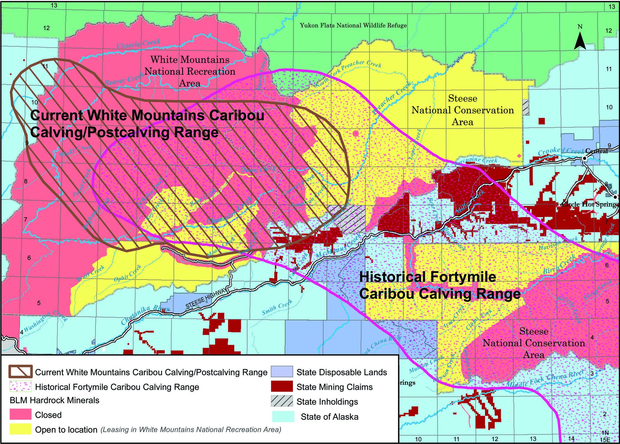
This figure displays lands recommended open to hardrock mineral leasing in this Supplement or to location in Alternative D
of the Draft RMP/EIS relative to areas historically used by the Fortymile caribou herd as calving habitat and the current
White Mountains caribou herd calving/postcalving range. The core of the Fortymile calving range was roughly centered on the
heads of Bear and Quartz Creeks from the 1900s through the 1950s before shifting southeast towards the current calving range,
centered on southern Yukon-Charley Rivers National Preserve.
Dall sheep habitat occurs in and adjacent to northern portions of the hardrock mineral leasing area. A Dall sheep mineral
lick occurs 0.7 mile from the mineral leasing area in upper Little Champion Creek. The Roy Creek REE deposit is utilized by
Dall Sheep during the rutting season. Hobgood and Durtsche (1990) mapped the ridgeline in this area as rutting habitat. The
area was not included in a recent delineation of medium-to-high Dall sheep use based on a 2004-2008 study of radio-collared
Dall sheep, but that study did document short-term use by one ram during the rut, supporting the earlier designation. The
scattered granite tors on the ridge between Quartz, Champion, and Bear creeks are utilized by Dall sheep in all seasons. Although
not included in the area to be opened to leasing, this ridge is likely to be utilized for access to leases.
The hardrock mineral leasing area contains relatively high densities of moose, during at least the October through April time
period. Rut concentrations in the area were identified by Durtsche et al. (1990). High-quality riparian and aquatic habitats,
including salmon spawning and rearing and high densities of Arctic grayling, support aquatic and terrestrial wildlife species.
Nutrient transfer from aquatic to upland environments increases productivity of upland habitats. One known peregrine falcon
nest site occurs in the hardrock leasing area and a gyrfalcon nest site occurs adjacent to the hardrock leasing area. Redtail
hawk nest throughout the leasing area, often near streams.
Environmental Consequences
The effects on wildlife from mining (and exploration) of known deposits of hardrock minerals in the White Mountains Subunit
under mineral leases would be similar to those described for locatable mineral development elsewhere in the planning area
(BLM 2012a, section 4.3.1.12). Lease procedures (including Leasing Stipulations) allow the BLM to manage development of leases
so as to reduce impacts to a greater extent than management under the locatable mineral laws and regulations (43 CFR 3809),
but the nature and types of impacts would be similar.
Hardrock mineral leasing in Alternative D would result in an estimated direct disturbance from exploration and mining of 661
acres of terrestrial wildlife habitat. In addition, 20 miles of road is estimated to be built for access. Much of the surface
disturbance from mining and access would occur to riparian areas and wetlands habitats which are typically high-value wildlife
habitats. Effects of surface disturbance of these habitats would extend, to some extent, downstream into Beaver Creek WSR
(e.g., through effects on turbidity or fish migration). Human activities associated with mines would reduce use of riparian
habitats by many wildlife species in the immediate vicinity of the activity.
Changes in access and resulting increases in human use of the area may have a greater effect on wildlife and their habitats
than direct habitat disturbance from mining-related activities. Most of the leasing area is not accessible via existing trails
and much of the existing network of trails (mostly user-created) is susceptible to degradation from increased use. Mining
activities would require much heavier use than the current levels of use (much of which is related to hunting) and for longer
periods. Vehicles larger than allowed under OHV designations would be permitted in some cases, likely creating proportionally
greater disturbance. The linear amount of new access has not been determined, but if each of the estimated 29 suction dredge
and placer operations and exploration leases resulted in an average three miles of new trails (or seriously degraded existing
trail), about 87 miles of such new or seriously degraded trail might be predicted.
Winter overland moves would often require clearing of vegetation. The linear clearings created may lead to summer use by OHVs
and establishment of new OHV trails. The network of mining access trails would be utilized by lessees and recreationists to
reach previously inaccessible areas, within which additional new trails may be created, resulting in further expansion of
trail networks. Similarly, roads built for mine access would facilitate much greater OHV activity in the area in which they
are constructed. In general, motorized access would increase throughout the hardrock leasing area, especially in the high
potential areas. In addition to direct changes in habitat from user-created trails, the creation and use may also facilitate
the establishment and spread of invasive plants, especially in areas recently burned.
Although little Dall sheep habitat is within the identified hardrock leasing areas, human use of additional access to sheep
habitats in the Upper Champion Creek and Quartz Creek area may reduce sheep use of those habitats.
Moose may benefit from some ground disturbances that result in growth of deciduous browse species, such as willow. Increased
hunting pressure and harvest in previously remote areas would likely reduce harvest in areas with already-established access,
such as Nome Creek. Hunting pressure may result in some displacement of moose from high-density rutting areas.
Most of the estimated 661 acres of habitat disturbance would occur within the historical calving range of the Fortymile caribou
herd and current calving area of the White Mountains caribou herd (Figure M.3). The White Mountains caribou herd has a dispersed
calving distribution and the hardrock leasing area comprises a small proportion (11 percent) of the current White Mountains
caribou herd calving/postcalving area. The much larger Fortymile Herd calves in a dense distribution. More than half of the
hardrock leasing area of high development potential occurs within the area of concentrated calving identified by Olson (1957)
for the Fortymile herd in 1956. Exploration of the Roy Creek REE deposit is estimated to result in disturbance of 50 acres
of current and historic caribou calving habitat. Exploration activities would be required to occur outside of calving/postcalving
season in this area, limiting impacts from those activities. The greatest impact to caribou would likely be the change in
access, human infrastructure, and the generally increased levels of human activity in the area. Although anticipated placer
gold mining operations in the area may have little direct effect on caribou use of the area, the combined direct and indirect
effects from changes in access and human use patterns in the area would likely reduce the suitability of the area as calving
habitat and potentially reduce the likelihood that the Fortymile Herd would reestablish a habit of calving season use of the
White Mountains. The overall level of disturbance, including linear disturbance, and human activity within the calving area
would influence the likelihood of use by caribou.
Compared with other large migratory caribou herds, the Fortymile herd’s current annual range has a low proportion of range
above treeline (17 percent; Boertje et al. in press). Boertje and others (in press) surmised that overgrazing of the herd’s
current core upland tundra habitat may have resulted in reduced herd nutrition levels and suggested that expansion to additional
spring and summer upland tundra in the White Mountains may be of key importance to realizing continued herd growth.
Several species of migratory birds are dependent on (or found in much higher densities in) riparian habitats. Placer mining
would remove habitat for these species in localized areas and habitat recovery may require several decades. Regardless of
when the vegetation clearing occurs, impacts from the changes in vegetation would persist probably for many years. ROPs (Appendix
A) protect only currently nesting birds. Nesting peregrine falcon and gyrfalcon are more likely to be affected indirectly
by changes in access than directly by mining activities. Nesting redtail hawk may be displaced by nearby placer mining and
dredging activities. These impacts are not expected to result in planning area population level declines of any species of
migratory birds.
Cumulative Effects
Hardrock mineral leasing in Alternative D would add to the cumulative impacts from exploration and development of locatable
and leasable minerals elsewhere in the planning area, including on state and private lands.
In Alternative D, with this supplement, 26 percent of the current White Mountains caribou calving/postcalving area would be
open to leasing of hardrock minerals. A much higher proportion of the Fortymile herd’s historical (prior to 1963) would be
open to leasing (Figure M.3). Almost the entire 38-mile segment of historical calving and migration habitat between Mount
Prindle and Clum’s Fork calving area would be open to location or leasing of hardrock minerals (Fig 3.4). The addition of
hardrock mineral leasing would further decrease the likelihood that Fortymile caribou would reestablish a tradition of calving
in the White Mountains vicinity. Given the relatively small amount of alpine habitat within the range of the Fortymile herd,
re-occupation of the calving and postcalving habitats in the White Mountains may be necessary for maintenance and growth of
the Fortymile caribou population.
The development of mines and associated access in the hardrock leasing area during the life of the plan would likely make
additional mines more economically feasible to develop in later years, possibly including the Roy Creek REE deposit. This
could expand the intensity and zone of impacts to wildlife beyond that predicted during the life of this plan, including additional
caribou and Dall sheep habitats.
M.3.2.9 Recreation and Travel Management
Affected Environment
Previous placer mining has affected recreation use in both positive and negative ways. Many of the trails now used in the
White Mountains NRA were developed as mining access routes and formed the basis the trail development plan in the Recreation
Activity Management Plan (BLM 1986). Alaska’s history of mining is of interest to many recreation visitors. Mining has helped
to provide some of the recreation opportunities that still exist in the NRA today and provide for a rich cultural context
of the landscape and its uses.
In contrast, active mining operations and related infrastructure has the potential to have negative effects for those recreation
visitors seeking a more primitive form of recreation experience, particularly in summer, when the effects of mining are more
visible. The experience expectation for primitive recreation includes a feeling of solitude and closeness to nature. The 2007
and 2009 Benefits Based Management studies for the White Mountains (Fix 2007, Harrington and Fix 2009) demonstrated that in
Nome Creek valley and adjacent areas of the NRA, awareness of the natural world, awareness of minimum impact recreation, and
family bonding were rated as important to over 60 percent of the respondents. Highest rated activities in these areas included
hiking, walking, hunting big game, berry picking and ATV riding.
The areas currently managed as a Semi-Primitive zone did have historic mining activity prior the 1980 Congressional designation.
These areas were targeted for development in the Recreation Activity Management Plan (BLM 1986) to improve and sustain existing
access routes and provide for a semi-primitive experience including OHV hunting opportunities, scenic qualities, recreational
access to primitive areas and river put-in, wildlife viewing, and hiking opportunities. Since 1986 two campgrounds, a non-motorized
hiking trail, a series of motorized summer and winter trails, recreational cabins, and river put-in have been established.
These planned infrastructure developments have been entered into BLMs Facility Asset Management system and the BLM receives
an annual budget for maintenance and program management.
The White Mountains NRA has quickly developed into an easily accessible recreation destination with a steady increase from
1,200 user days in 1986 to over 12,000 user days in 2011. The bulk of this visitor use increase is in the Semi-Primitive zones.
Very little historic mining occurred in areas currently managed for a primitive recreation experience. Any historic mining
in the Primitive zone took place prior to the Congressional designation in 1980. Areas managed for a semi-primitive experience
in the NRA have not seen mining activity for 20 years or more.
Environmental Consequences
Direct impacts to recreation include visual impacts, short-term user conflicts, and noise impacts. A formal study was conducted
in 1988 for placer mining activity in Beaver Creek. The Beaver Creek Placer Mining EIS (BLM 1988b) found that negative impacts
to primitive recreation experiences can result from views of the old claims and disturbance to the landscape in the adjacent
recreation management zone. Impacts resultant from active mining is also caused from being able to hear the equipment or see
the effects on water quality. These impacts may be mitigated with the ROPs and stipulations analyzed for each action and may
be more tolerated over time by the affected user groups.
The anticipated continuous noise production for suction dredging is expected to occur up to four hours per day over a ten
hour period in the same location. This continual noise could displace some recreation visitors anticipating a backcountry
experience under the current recreation management classification. The RFD suggests that there would be 11 such leases. Lands
immediately adjacent to the area recommended open for suction dredge leases are currently managed for primitive recreation
setting. There are some large trees adjacent to the creeks in many areas that could dampen the noise levels and shield passersby
from the undesirable experience.
The smell of exhaust from a continuously running engine associated with a suction dredge may impact some users by displacing
them out of range of the exhaust fumes. Though similar to the exhaust fumes from an ATV, the exhaust smell from a stationary
operation would not pass by the recreationalist, but creates a situation where the recreationalist has to displace their intended
route to avoid the smell.
Buffers around BLM-maintained facilities (ROPs R-1 and R-2) would be implemented in areas of high and medium development potential
(Figure M.1), the terrain is hilly, the trees are small or non-existent and sight distances can be miles long. Views of mining
activity would be visible from ridge tops. The visual resource management ROPs would reduce visual impacts.
The Table Top Trail was designed as part of the White Mountains Gateway Project in 1987. It was designed to give non-motorized
users a place to go in the midst of an area intensively managed for many uses, including various types of developed facilities
including roads, OHV trails, and campgrounds. The trail crosses a ridge top with views to the ridgelines to both the north
and south. Mining activity would be visible toward the north. Visual impacts may be mitigated with the ROPs.
Occupancy of mining equipment and related operations may impact as much as 0.2 acres of land for approximately 90 days per
operation and impact some recreation users that would be displaced as far as necessary to be out of sight of the camp and
out of audio range of the mining operation. This could potentially be miles away. Proper location of camps and staging areas
could reduce this impact.
Occasional increases in turbidity levels occurred 30 to 50 miles downstream of active mining in Nome Creek (BLM 1988b, Webb
1982), a primary tributary of Beaver Creek WSR. It is conceivable to assume that new mining activities in Bear, Champion,
Little Champion, Ophir, and Trail Creeks could produce similar increases in turbidity especially if mining activity was occurring
on more than one creek at the same time, however under the current mining regulations, turbidity levels should be greatly
reduced. All of the aforementioned creeks flow into Beaver Creek. Increased turbidity or muddy water, inherent with mining
activities, would reduce the aesthetic appeal of Beaver Creek and negatively influence the floating experience by boat floaters
(BLM 1983). The semi primitive recreation management zones are managed for naturalness including clear, free flowing streams
with the appearance of being untouched and undisturbed by humans. Beaver Creek supports a popular grayling fishery. Fishing
success would decrease in muddy water and displace some users. River hazards are more difficult to identify in muddy waters
which increases floating difficulty.
Cumulative Impacts
Indirect and cumulative impacts from the activities and infrastructure associated with mining activities and exploration include
the related travel and access to lease locations as well as the increase of recreational users accessing these new access
routes. The geographic area of consideration for cumulative effects is the White Mountains NRA.
Access routes to leases could benefit other users if trails were constructed in the proper locations and use sustainable trail
construction techniques. Cross-country travel is allowed under alternative D, however, the addition of more concentrated routes
with multiple passes over the same area would compact the soil and vegetation and create a permanent scar on the landscape.
User-created trails or routes created by four-wheelers are not typically sustainable because they tend to go straight up and
straight down hills, which creates a path for water to accelerate and intensify erosion. User-made trails deteriorate over
time. They become difficult to travel and negotiate with an OHV. This can develop into a safety hazard. Roads and trails associated
with mining operations are attractive to motorized recreation users. While contributing to greater access by the motoring
public, it will also greatly expand the proliferation of user-made trails and multiple routes to the same location. The cumulative
impact of such actions may result in increased costs for BLM administration of the recreation area and maintenance of new
and unsustainable travel routes. These impacts may be mitigated during site-specific NEPA analysis when access routes for
each exploration license or lease block is identified, and routed in the most appropriate location.
Mining activity is expected to occur adjacent to Backcountry and Semi-Primitive recreation management zones which are closed
to the summer use of OHVs (April 15 through October 30). Mining access routes could attract more ATV users into these border
areas where there is currently little to no motorized activity. Access into Bear and Quartz creeks, where suction dredge leasing
would occur (and mechanized placer mining in Bear Creek), is generally on north facing slopes typical of black spruce forests
and tussock tundra. These areas are underlain with permafrost near the surface and have slopes greater than 20 percent. These
environmental conditions can be difficult obstacles for building trails or any kind of sustained access.
The Trail Management Objective (TMO) for managed OHV trails in the White Mountains NRA are for a type 2 semi-primitive motorized
trail and describe access as “more difficult” with a tread width of 72 inches maximum and clearance width of 6 to 8 feet.
The trails are not developed for access by vehicles other than ATVs and snowmobiles (generally 1,000 pounds or less curb weight
and not exceeding 50 inches in width). Any mobilization of mining equipment on these trails would require the trails to be
widened. A wider trail corridor could attract use of vehicles larger than allowed by current OHV regulations. Sixty-one miles
of these trails are designed for winter use and are not maintained for summer use due to wet and boggy soil conditions. An
increase in summer use on these little-used trails will have adverse effects on winter trails. Summer use causes rutting and
erosion making winter trail maintenance difficult and reducing the quality of the trails for winter uses. Trail drainage structures
currently in place would not accommodate larger vehicles.
The Quartz Creek Trail is a hardened, sustainable trail located in the area of high development potential and would be an
attractive access route for mining activity. The trail is currently designed for a three-year maintenance schedule. With the
anticipated increase in use, the maintenance schedule may have to be accelerated to every year. To date, there has been a
significant investment of public funds into this trail, which would increase with additional maintenance needs.
According to the RFD (BLM 2012b) up to 20 miles of road could be considered for access into Bear and Quartz creeks. Up to
10 miles of road could be considered for access into Ophir Creek. Roads also attract a larger vehicle types not associated
with the mining activity that are beyond the scope of the management objectives for travel management in the NRA. Larger vehicles
(over 50 inches in width and greater than 1,000 pounds curb weight) would likely leave the road for cross-country travel and
create some enforcement issues. Indirect effects from road construction include the reclamation of road beds after the life
of the mine or the maintenance and redevelopment of sustainable road infrastructure by the BLM and would require additional
expense and maintenance beyond the life of the plan.
Direct effects to recreation are expected to be short-term and could be mitigated through the ROPs or stipulations associated
with NEPA analysis of each exploration or leasing action. The access needs and infrastructure associated with the mining activity
will increase the proliferation of user-created trail networks in a heavily used area. The proximity to Fairbanks, growing
popularity of the area, existing recreation facilities, layered with new user and travel access needs are expected to have
a cumulative adverse effect on the administration of the recreation area.
M.3.2.10 Subsistence
Affected Environment
The affected environment is discussed in more detail in Chapter 3 of the Draft RMP/EIS (BLM 2012a) and the fish and wildlife
sections of this document.
The areas recommended open to mineral leasing through this supplement are within the current White Mountains caribou herd
calving and postcalving area and the historic calving and postcalving range of the Fortymile caribou herd. Caribou are most
vulnerable to disturbance during these periods. The area is also important current winter range for White Mountains and Fortymile
caribou. The northern portion of the area, which includes the Roy Creek REE deposit and upper Bear and Quartz creeks placer
gold, are current and historic high use calving and postcalving areas for both caribou herds. Dall sheep movement corridors
and habitat are within and adjacent to the area proposed for hardrock mineral leasing. The area contains relatively high densities
of moose during rut and winter seasons (October through April).
Fortymile caribou are among the most important subsistence resources in the planning area. As Yukon River salmon stocks decline,
Fortymile caribou become increasingly important to subsistence users in and adjacent to the planning area. Research on land
use patterns by rural residents indicates that residents of Birch Creek Village area moved seasonally into the White Mountains
to harvest caribou and sheep (Caulfield 1983). Contemporary harvest data indicate little current use of White Mountains caribou
and Dall sheep by rural subsistence hunters however use of these populations could increase in importance over the life of
the plan and should not be discounted (Subsistence Resources, White Mountains Subunit, Draft RMP/EIS).
Environmental Consequences
Impacts on subsistence resources and uses within areas recommended open to mineral leases and exploration licenses in the
White Mountain NRA include user conflicts, displacement of resources, and potential declines in resource availability due
to disturbance in critical habitats (spawning) or during critical times (e.g., calving periods). Alternative D, which also
allows the most latitude to OHV use and rights-of-way development and identifies the smallest area of protection for wildlife
habitat, would have the highest negative impacts on subsistence of all alternatives considered.
ROPs and stipulations developed in the draft RMP/EIS and Supplement (Appendix A) to mitigate the impacts of land use actions
on subsistence wildlife resources would be attached as stipulations to the authorizing documents. Minimal direct impacts to
subsistence wildlife resources or uses would occur from hardrock mineral leases and exploration licenses because no exploration
activities would be allowed in Dall sheep habitat from May 10 through June 1 or in caribou calving and postcalving areas from
May 15 through July 15. Exceptions would be allowed when it can be demonstrated that caribou or Dall sheep do not occupy the
area (Table M.6, Stipulation 5). Therefore, no direct impacts on abundance of subsistence wildlife resources is expected from this plan decision.
Indirect impacts are expected to be greater and more difficult to mitigate. Increased access to largely remote wildlife habitat
is expected to occur as roads to support placer mining are developed and areas cleared of vegetation for winter overland moves
become used as summer OHV pioneered trails (section M.3.2.9 Recreation and Travel Management, of this appendix). The resulting
increase in non-mining activities may reduce the suitability of the areas for calving and postccalving. Analysis of data on
Fortymile caribou habitat condition indicates that current calving and postcalving range has been diminished from overgrazing
and limited suitable habitat is available. The research indicates that this area of the White Mountains NRA will become increasingly
important to continued growth and stability of the Fortymile caribou herd (Boertje et al. in press). Analysis of indirect
impacts to Fortymile caribou from mineral leasing resulted in a finding of may significantly restrict subsistence use of Fortymile
caribou (See the ANILCA Section 810 Analysis in Appendix B of this document for further analysis and findings.)
Some conflicts between hardrock-leasing related activity and federal qualified subsistence users may occur from mid-August
through September and from November through March if exploration and placer mining is active during these time periods. Access
by subsistence hunters may be restricted due to perceived or real barriers to wildlife resources. As a result, hunters may
be displaced to other areas. When caribou are in the area during seasons open to hunting they are generally distributed over
a wider area, thereby minimizing access issues for subsistence hunting. Moose are available through the greater area and much
of the rural resident harvest of moose occurs away from the area open to hardrock mineral leasing, although distribution of
moose hunters could change due to increased access into the area. Conflicts among hunters are not expected to be significant.
Ophir Creek, a tributary of Beaver Creek, has been identified as an area with high development potential for placer gold in
Alternative D. Spawning areas for Chinook salmon have been identified within Ophir Creek. Because active mining is likely
to occur in and adjacent to these spawning areas, direct impacts on this population are expected.
Indirect impacts to subsistence fish species and local water quality from mineral leasing may occur downstream due to turbidity,
crossing of streams, high water events and occasional failure of settling ponds (sections M.3.2.4 Soil and Water Resources
and M.3.2.2 Fish and Aquatic Species). These impacts are likely to be short-term. Regulations and ROPs that require recycling
of turbid water through settling ponds and reclamation of disturbed stream channels should mitigate most of these impacts.
Cumulative Effects
Cumulative effects may significantly restrict subsistence use of Fortymile caribou due to past, present and reasonably foreseeable
actions within the herd’s range. The impacts are the same as those described for Alternative D when considered with the cumulative
case for the Fortymile and Steese Subunits (BLM 2012a Appendix J).
For subsistence fisheries resources, when analyzed with the cumulative case, impacts may incrementally contribute to the downward
trend and resiliency of Yukon River Chinook salmon stocks. Chinook salmon are highly important subsistence species within
the Yukon River drainage. The Alaska Board of Fish (Board) classified the Yukon River Chinook salmon stock as a stock of yield concern in 2000 (Howard et. al., 2009). Each regulatory cycle the Board reassesses the stocks and Yukon River Chinook salmon have
remained a stock of concern as it continues to decline with lower returns each year and harvestable yields not being maintained.
Genetic diversity of these small stocks, such as the Ophir Creek population, are extremely important for resiliency of the
Yukon drainage stocks and are often overlooked in impact analysis (JTC 2012). Due to declines of the Yukon River Chinook salmon
stock and the importance of Chinook salmon to Upper Yukon subsistence villages, analysis of Alternative D with the cumulative
case has resulted in a finding of may significantly restrict subsistence use of Chinook salmon within the Upper Yukon River
including and downstream from the village of Beaver.
M.3.2.11 Social and Economic
Economic Effects
An economic effect in the White Mountains Subunit continues to result from recreation oriented activities as a result of population
growth in the region. Economic effects due to mining on non-federal land and on existing federal claims outside of the White
Mountains NRA, but within the subunit, would also continue to be important to the region. There are federal, state, and patented
mining claims in the Livengood area with ongoing mineral exploration. Exploration and leasing for placer gold and rare earth
mineral exploration would result in positive economic effects from this subunit under Alternative D.
The following discussion is based on gold mining activities likely to occur on land leased for placer or suction dredge mining
(Stebbins 2009). Section 4.4.4.1.2 Fortymile Subunit, Effects from Locatable Minerals of the Draft RMP/EIS (BLM 2012a) outlines
the Stebbins models for small- and large-scale placer mines, life of mines, and a background discussion of the types of economic
impacts and is incorporated by reference.
Economists consider three categories of employment and income in considering the effect of an activity such as mining. These
three categories are: direct employment and income, including only employees of mining companies; Indirect employment and
income such as employees of businesses providing goods and services to mining companies: and, induced employment and income
occurring when jobs are created as a result of spending of direct and indirect income attributable to mining activity. All
employment and income shown in this analysis is estimated using input and assumptions from BLM reports (Stebbins 2009, BLM
2009) and McDowell reports (2006 and 2009).
Opening the identified lands in the White Mountains NRA to hardrock mineral leasing under Alternative D is predicted to result
in large and small-scale placer mining operations. Small-scale placer mining uses a bulldozer, and excavator and a mobile
wash plant to excavate and process gold-bearing gravel. In this model, a two-man crew works 12 hours per day, seven days per
week, during a 130-day season. The camp includes one support person and a cook; a total of four workers. Eleven small-scale
placer mines are forecast to operate with employment of about four workers each.
Large-scale placer operations utilize excavation equipment larger than the small-scale model. In this model, 2 two-man crews
moving material each work a 10-hour shift, seven days per week, during a 130-day season. Five additional employees, including
a supervisor, skilled workers, and laborers; a total of nine workers are included in the model. Assuming two large-scale placer
mines, the resulting employment is about eighteen workers.
Suction dredging would occur on about 11 new leases. These would employ approximately two workers per operation, for all phases.
In addition, the BLM development scenario indicates approximately four licensed placer exploration efforts. These are included
in direct income calculations show in Table M.3.
The total mining employment on BLM-managed lands would be estimated at 84 part-year workers. Data prepared by the State of
Alaska uses full-time equivalents. The full-time equivalent in the White Mountain Subunit would be approximately 33 workers,
based on the Stebbins (2009) models. Total employment by the Alaska minerals industry in 2008 was 3,392 full-time equivalent
jobs (Szumigala et al. 2009). The statistics indicate less than one percent of the industry employment on BLM-managed lands
would occur at White Mountain operations. The DGGS reported the average monthly wage for mining in Alaska during 2010 at $8,345.
White Mountains gold mining operations account for approximately $3 million in wages, annualized. Jobs data indicates maximum
level of effect predicted to occur during the life of the plan. Development scenarios used as the basis for analysis do not
contain time lines for development. Mineral exploration licenses or leases may not be issued for years after the plan is completed.
Direct Employment and Income for New Mining
| Activity | Crew | Alternative A | Alternative B162 | Alternative C | Alternative D | |||||||
|---|---|---|---|---|---|---|---|---|---|---|---|---|
| Current Operations | Current Jobs | New Operations | New Jobs | New Income | New Operations | New Jobs | New Income | New Operations | New Jobs | New Income | ||
| Fortymile Subunit | ||||||||||||
| Suction Dredge | 2 | 6 | 12 | 4 | 8 | $278,122 | 8 | 16 | $566,244 | 12 | 24 | $834,366 |
| Small Placer | 4 | 27 | 108 | 4 | 16 | $578,142 | 6 | 24 | $867,212 | 13 | 52 | $1,878,960 |
| Large Placer | 9 | 2 | 18 | 1 | 9 | $325,204 | 1 | 9 | $325,204 | 1 | 9 | $325,204 |
| Total | 35 | 138 | 9 | 33 | $1,181,468 | 15 | 49 | $1,748,660 | 26 | 85 | $3,038,530 | |
| Steese Subunit | ||||||||||||
| Suction Dredge | 2 | 1 | 2 | 0 | 0 | $0 | 8 | 16 | $556,224 | 11 | 22 | $764,836 |
| Small Placer | 4 | 7 | 28 | 1 | 4 | $144,535 | 8 | 32 | $1,156,283 | 17 | 68 | $2,457,102 |
| Large Placer | 9 | 2 | 18 | 0 | 0 | $0 | 2 | 18 | $650,409 | 2 | 18 | $650,409 |
| Total | 10 | 48 | 1 | 4 | $144,535 | 18 | 66 | $2,362,916 | 30 | 108 | $3,872,347 | |
| Upper Black River Subunit | ||||||||||||
| Suction Dredge | 2 | 0 | 0 | 0 | 0 | $0 | 0 | 0 | $0 | 0 | 0 | $0 |
| Small Placer | 2 | 0 | 0 | 0 | 0 | $0 | 0 | 0 | $0 | 0 | 0 | $0 |
| Large Placer | 9 | 0 | 0 | 0 | 0 | $0 | 0 | 0 | $0 | 0 | 0 | $0 |
| Total | 0 | 0 | 0 | 0 | $0 | 0 | 0 | $0 | 0 | 0 | $0 | |
| White Mountains Subunit | ||||||||||||
| Suction Dredge | 2 | 0 | 0 | 0 | 0 | $0 | 0 | 0 | $0 | 11 | 22 | $764,836 |
| Small Placer | 4 | 3 | 12 | 0 | 0 | $0 | 0 | 0 | $0 | 11 | 44 | $1,589,889 |
| Large Placer | 9 | 1 | 9 | 0 | 0 | $0 | 0 | 0 | $0 | 2 | 18 | $650,409 |
| Total | 4 | 21 | 0 | 0 | $0 | 0 | 0 | $0 | 24 | 84 | $3,005,134 | |
The BLM plans to open 11,000 acres of known deposits at the headwaters of Roy Creek to mineral leasing and predicts that it
will eventually issue competitive leases for deposits of certain rare earth elements under 43 CFR part 3500 on these lands.
The lease is offered competitively and a royalty may result. The BLM will charge fair and reasonable rental, determined at
the time of licensing or leasing. These rentals are exclusive of royalties.
Exploration activities could include mapping and drilling or trenching in the lease area over a five year period. Income
effects would depend upon the size of the initial operation, which may begin with as few as three personnel plus a helicopter
crew, all based off site. It is fair to assume the minimum cost of exploration over a 120 day period would average approximately
$2,000 to $2,500 per day. This is $240,000 to $300,000 per season in overall cost. The cost is essentially field personnel,
helicopter contract, and fuel. Part of this cost would be attributed to the Fairbanks economy. Beyond the initial exploration,
expansion of activities may occur, including further drilling and delineation, and eventual mining operation. Additional NEPA
analysis will be necessary on a case-by-case basis for the BLM decision to lease for production.
There are no special recreation permits in the area of likely mineral development. No impacts to commercial recreation permits
are anticipated (section M.3.2.9). The likely economic effect in an area of little or no commercial recreational activity
is zero.
Section M.3.2.10 Subsistence reports: "Contemporary harvest data indicate little current use of White Mountains caribou and
Dall sheep by rural subsistence hunters however use of these populations could increase in importance over the life of the
plan and should not be discounted (Subsistence Resources, White Mountains Subunit, Draft RMP/EIS)." Given that there is little
or no documented subsistence use in the White Mountains NRA, an economic effect is unlikely.
Environmental Justice
Communities most likely to be affected by increased activity in the White Mountains Subunit are (Fairbanks and Livengood)
do not qualify as environmental justice populations. Minority or low income populations in the Fairbanks area may benefit
from employment in the recreation and mining industries. Under Alternative D, the number of special recreation permits in
the planning area would be slightly higher than other alternatives. New mining leases and mineral exploration could result
in additional employment accruing to local populations. Minority and low income populations would not be disproportionately
impacted.
Possible negative impacts to environmental justice populations and the entire population of the area include loss of employment
in another existing industry due to mining development. However, there are no commercial activities in the area potentially
opened to mining under Alternative D providing employment that will be affected. All populations may benefit from expanded
recreation industry employment as well as mining employment within the White Mountains Subunit. This includes additional land
outside of the White Mountains NRA.
Loss of subsistence resources or opportunity may be considered. However, the extent of subsistence use of the specific areas
likely to be affected must be demonstrated before there is an attributable and measurable impact. Current data indicate little
subsistence activity in these areas. The Fairbanks North Star Borough is also classified as a non-rural community as such,
residents of the borough do not quality to fish or hunt under federal subsistence regulations.